
Aerial view of the City of Beja, with the walls of the Castle of Beja, the Port of Évora, the Cathedral, and the view of the surroundings
In this article, you will get to know about...
Beja
The city of Beja is an ancient city located in the lower Alentejo, with a traditional agricultural culture, landscapes marked by plantations, and streets and squares with markedly historical and ecclesiastical features. In Beja we find a great diversity of attractions, a city surrounded by the countryside, with castles and museums, natural parks and religious buildings. It is a city where we find the historical memory very present in the churches, convents and monuments that characterize the bejense landscape. The old facet of the Alentejo city intersects with the passage of other peoples, such as the Moors or Visigoths, who influenced the culture and customs of Beja, also stamped on the city's coat of arms, where a bull symbolizes an ancient narrative. Legend has it that a dark snake terrified the inhabitants of Beja, when the population decided to place a poisoned bull in the forest in order to get rid of the creature. It is this type of tales and myths that lend a mysterious side to the Beja region, and fill the imagination of all those who visit the city of Beja. Beja is the country's hottest district capital, with mild winters, and hot, long summers.
Attractions to visit in the city of Beja
The historic center of the city of Beja:
Praça da República: is the heart of Beja, which corresponds to the political and administrative center of the city. It was in this square that parties, bullfights, plays during the Middle Ages and the Age of Discoveries were held. Praça da República features buildings such as the Igreja da Misericórdia, the seat of the Regional Conservatory of Baixo Alentejo housed in a 16th century palace, Finance in a 17th century palace, the old city jail and the Town Hall inaugurated in 1953. The Largo de Santo Amaro, the place where the agrarian reform market functioned after the 25th 1974, deserves to be highlighted by the Igreja de Santo Amaro, where we find the Visigothic Nucleus of the Regional Museum from Beja. Largo de São João, the most recent area of the historic center. Its main attractions are the centenary Clube Bejense, the Cine-Teatro Pax Julia opened in 1928, a sculpture by Noémia Cruz in the center of the square, and Travessa do Cepo, which integrates the medieval city of Beja, with emphasis on the Gothic arch. The Rua do Sembrano, highlighting the Núcleo Museológico da Rua do Sembrano, which includes the walls of the Iron Age, ruins of Roman baths and panels of modern tiles alluding to the theme of water and authorship by the painter Rogério Ribeiro. And the Praça Diogo Fernandes, with emphasis on the Jardim do Bacalhau where we find a modern iron sculpture by Jorge Vieira dedicated to the Unknown Political Prisoner.
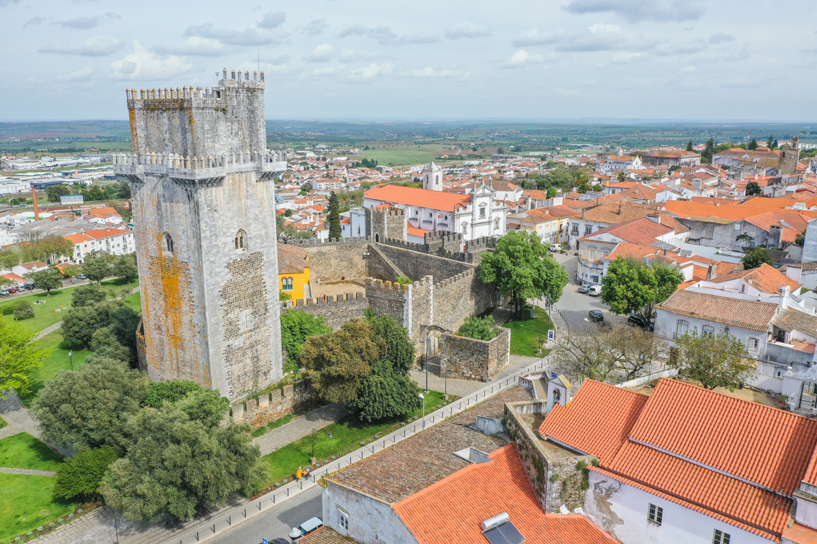
Beja Castle
Castelo de Beja: it is the most popular and emblematic monument in Beja, a well-kept medieval castle located in the center of the city, with a wall that surrounds the old city. Beja Castle is known for having the highest keep in the Iberian Peninsula, almost 40 meters high, and an incredible vault with an eight-pointed star. The castle has an imposing presence thanks to its tower and due to the architectural characteristics of the Manueline, Gothic, Mannerist and Romanesque styles. It is a monument directly linked to the history of Portugal, where we can visit the Casa do Governador, the wonderful keep, and walk along the perimeter of the walls that surround the old city with a privileged panoramic view over Beja and the surroundings of City. The old fence of Castelo de Beja was composed of forty towers and four main doors, the doors of Évora, the doors of Mértola, the doors of Avis and the doors of Aljustre. Over the centuries, three doors were added to the wall, the Moura doors, São Sisenando doors and the Corredoura doors. The Porta de Évora, also known as the Roman Arch of Beja, is the main entrance next to the castle. Inside the castle we find since 2019 the museum of contemporary art Jorge Vieira.
Beja City Park
The Parque da Cidade is a typical leisure garden much sought after by the local population. Located to the west of the city of Beja, it was built in 2004 with an extensive lake located in the center, several gardens for recreational activities and utilities. Here we find a restaurant, terrace and kiosk, a playground, a small half-pipe for skates and skates, an area dedicated to pets, tables and benches for picnics. There is an area with sports equipment to be used by visitors. The Parque da Cidade de Beja stands out from the urban landscape, due to the existence of many green spaces, where we glimpse a great diversity of plants, namely willows, poplars, fig trees and typically Alentejo cork trees. This park ensures an environmental improvement in the region with its green spot, and serves as a stage for activities as varied as ball games, hiking, cycling, reading or yoga.
Attractions to visit in the Beja district
Natural Park of Southwest Alentejo and Costa Vicentina
Sudoeste Alentejano e Costa Vicentina Natural Park: it is a natural park assumed as one of the most beautiful coastal areas in the world, with a coastal extension exceeding 100 km, bounded to the north by the Junqueira stream in São Torpes, in the district from Setúbal and to the south by Burgau beach in the Algarve, Faro district. The park is one of the pearls of the Alentejo due to the great diversity of monuments, islets, wild beaches with Atlantic ripples, limestone cliffs, protected vegetation, migratory birds, walking paths, small towns and villages, and many points of interest that attract thousands of visitors every year. The beaches with extensive sand captivate the attention of surfers, while nature lovers visit the Natural Park of Southwest Alentejo and Costa Vicentina to discover the tip of Sagres, where we find the Fortaleza de Sagres in cabo of São Vicente. The appearance of the park undergoes radical metamorphoses from season to season, which attracts many visitors throughout the year. With dozens of beaches along the west coast and south coast, the Parque Natural do Sudoeste Alentejano e Costa Vicentina is known worldwide as a surf destination, from São Torpes to Zavial on the south coast, passing through dozens of beaches, listing from north to south the best known: Samoqueira beach, Buizinhos beach and Porto Covo beach in Porto Covo, Franquia beach and Furnas beach in Vila Nova de Milfontes, Almograve beach, Cavaleiro beach, Zambujeira do Mar beach, Amália beach, Adegas beach and Odeiceixe beach, Vale dos Homens beach, Carriagem beach, Amoreira beach at the mouth of Ribeira de Aljezur, Monte Clérigo beach and Fateixa beach in Monte Clérigo, Medo da Fonte Santa beach, Arrifana beach in Arrifana village, Pedra Agulha beach, Canal beach, Vale Figueiras beach, Bordeira beach and Amado beach in Carrapateira, Cordoama beach and Castelejo beach in Vila do Bishop; the beach of Ponta Ruíva in a place completely surrounded by wild nature, and the beaches in the village of Sagres, namely Praia do Beliche, Praia do Tonel, Praia da Marteta and Praia do Martinhal. The Natural Park of Southwest Alentejo and Costa Vicentina has the main natural attractions:
- As Cliffs and reefs on the island of Pessegueiro, Cabo Sardão, Carrapateira, Cabo de São Vicente;
- A Fauna, with approximately 200 species of birdlife, 26 of which nest on cliffs. Special mention should be made of the white stork (the only one in the world to make its nests on the sea cliffs), the peregrine falcon, the fastest bird in the natural park, reaching a diving speed of approximately 385 km / h;
- A Flora, with approximately 750 species of flora, of which 12 only exist in this location;
- The Banned Fishing Fluvial Areas, namely the Seixe riverside, de Aljezur river, Bordeira river and the Mira river;
- The Prohibited Fishing Maritime Zones, namely the Burrinho, Atalaia, Carraca, Agulha, Santoleiro, Baía da Nau, Gaivotas, Gigante, Ilha do Pessegueiro, Cabo Sardão, the islets of Martinhal and the area of Rogil;
Guadiana Valley Natural Park
Vale do Guadiana Natural Park is a protected natural park created in 1995 to preserve the section of the Guadiana River, located around the village of Mértola. The area of the park is limited to an area of plains, hills and valleys that extend along the hydrographic basin of the Guadiana Valley with an extremely rich fauna and flora, which include Mediterranean vegetation protected from human intervention, with the presence of rupicolous birds along the territory that constitutes the Natural Park. Here we find several hiking trails where we can observe birds, the park being an important corridor for migratory birds and habitat for birds of prey, and find some unique species in the world, such as the Saramugo fish. In addition to all these natural attributes, we can visit several attractions in the Vale do Guadiana Natural Park, such as the waterfalls of Pulo do Lobo, the museum-village of Mértola over a thousand years old , the Castelo de Mértola, the Hermitage of Nossa Senhora das Neves, the Mother Church of Nossa Senhora da Anunciação, the Museum of Mértola – Nucleus of the Paleocristan Basilica, the Ponte de Mértola a century-old bridge over the Oeiras stream declared a National Monument, the Fluvial beach Azenhas do Guadiana, the fluvial beach of Tapada Grande, and the Mina de S. Domingos, an abandoned mining complex. In the Natural Park of Vale do Guadiana it presents by main natural attractions:
- The Geosites, namely the Pulo do Lobo waterfall; the Stratigraphic Sequence of Pomarão with volcanic rocks with unique characteristics in the Iberian Peninsula, and with an approximate age of 350 million years; and the São Domingos mine, a mine explored from the Roman period until 1962, having been rich in copper, sulfur, gold, lead and zinc;
- The Heritage composed by the Amendoeira Landscape Interpretation Center, Monte do Vento Environmental Studies and Awareness Center, and the Tapada Grande River Beach;
- And the Points of Interest composed by Moinho dos Canais, Rocha da Galé, Azenhas do Guadiana, Penha da Águia, Ribeira do Vascão, Antas das Pias, Azinhal (Crane Feeding Area), Monte da Balança with steppe birds and the crows' dam.
Pulo do Lobo Waterfall
The Pulo do Lobo Waterfall is a waterfall located on the Guadiana River, accessed by the Herdade do Pulo do Lobo, characterized by the spectacular fall of crystalline waters to more than 20 meters in height through the closed rocks. The waterfall's water falls into the river violently causing a spectacular waterfall effect. The Pulo do Lobo Waterfall was mentioned as one of the natural wonders of Portugal. The name of the waterfall comes from a legend, which says that a wolf managed to cross the slender banks of the river with a single jump. Pulo do Lobo is a place of strong telluric energy, with the sound of the water, the misty atmosphere, the river current. The danger of falling exists for the most distracted, however the area recommended for observation of the waterfall is protected with a balcony. The banks of the Pulo do Lobo waterfall are rocky and steep, with the Guadiana River in the background. To access the waterfall on the Portuguese bank, we must enter Herdade do Pulo do Lobo, where we find a gate. At this point there is an indication that we can open the gate to enter, however they are grateful that we leave it closed after the passage.
Pessegueiro Island, Ilha de Fora Fort, Pessegueiro Beach and Nossa Senhora da Queimada Fort
Ilha do Pessegueiro: is a small island without any sand beach located south of Porto Covo, integrated in the Natural Park of Southwest Alentejo and Costa Vicentina. The only existing building on the island is the Fort of Santo Alberto do Pessegueiro, also known as Forte da Ilha de Fora, with the old function of crossing fires with the Fort of Nossa Senhora da Queimada, classified as National Monument, located next to the beach of Ilha do Pessegueiro. It is a military defense construction built on sandstone rock and has a pologional plan, reinforced by triangular bastions with embankment walls, built in the 17th century with the objective of preventing the advance of pirates. The 1755 earthquake caused extensive damage to the fortresses as a whole. In front of the island, on the mainland we find Praia do Ilha do Pessegueiro, a beach of approximately 750 meters of sand and rock, oriented to the west, located 2 km south of Porto Covo, in front of the Porto Covo Camping Park . This island was immortalized in the song "Porto Covo" composed by the Portuguese musician Rui Veloso.
Castle of Mértola
Mértola Castle: it is a castle erected in the 13th century by the Knights of the Order of Santiago, located in the village of Mértola (district of Beja) in an elevated position over the village and over the Guadiana river. It is a Gothic style castle, which has undergone several transformations and restorations over the centuries due to the presence of the Romans and Arabs. The Castle of Mértola includes a keep of approximately 30 meters, two smaller towers and a cistern in the center of the Plaza de Armas. The castle benefited from repair works in the last century and the Torre de Menagem serves today as an exhibition area for archaeological discoveries from the Roman, Visigoth, Islamic and Portuguese times. In addition to the historical attributes and the excellent state of conservation, one of the most praised aspects of the Castle of Mértola is the wide view of the village of Mértola and the Guadiana River through the top of the walls. From here we can see the other parishes. To the left of the Castle of Mértola we find the mother church, an old mosque converted into a church after the reconquest of the Christians.
Castelo de Moura
Castelo de Moura: it is a medieval building from the 13th century located on the left bank of the Guadiana, a time when Moura was occupied by Christians for the first time. The Portuguese took advantage of the fortifications left by the Arabs to build and increase the size of the castle as the population increased. Castelo de Moura has undergone several architectural changes over the years, the main highlights being the construction of the Convent of Nossa Senhora da Assunção and Towers of the Clock. In addition to the magnificence of the monument and the location right in the heart of the city of Moura, the castle is an attraction due to its rectangular Manueline style plan, and the Gothic style of the Keep, with the Sala dos Alcaides with an octagonal covered plan through a vault in the cross of warheads. The legend of Moura Salúquia says that the city of Moura was conquered from the Moors due to an error by Princess Salúquia, who mistakenly confused the brothers of D. Afonso Enriques masked in Muslim robes with Islamic knights, allowing them to enter the Castle . These defeated the Moors and conquered the fortress and village, renaming it "Terra da Moura Salúquia", originating the name of the city of Moura.
Centro Ciência Viva do Lousal
The Centro de Ciência Viva do Lousal is a dynamic space for knowledge and leisure, whose main objective is to disseminate scientific and technological culture to the population. The place invites you to travel back in time, where we can see a representation of the now extinct Lousal mine with thousands of miners in full operation. Although the scientific side and knowledge are the focus of Centro Ciência Viva do Lousal, there is also space to address other issues of the time through interactive content dedicated to geology, physics, chemistry, mathematics, computer graphics or biology. The industrial museum that currently houses the Centro Ciência Viva do Lousal was an old mining complex between 1934 and 1992. After some adaptations, this center started to have a virtual grotto, rooms for the exhibition of contents, a laboratory, an auditorium, a cybercafé and a viewpoint. The Ciência Viva Center is a fantastic way for families to combine knowledge and fun in a single activity.
Beja Regional Museum – Rainha D. Leonor Museum
The Museu Regional de Beja – Museu Rainha D. Leonor is the oldest museum in Portugal, having been inaugurated in 1791. It is located in the remains of the old Convento da Conceição, in the parish Santa Maria da Feira and the city of Beja. Also known as the Rainha Dona Leonor Museum, this space documents the different cultures present in the Alentejo from prehistory to the present through an immense collection, which came from other convents and palaces in the region. The main collection features pieces from Roman archeology, found during the empire of Julius Caesar, revealing the occupation of this territory. The museum has undergone several works of expansion and restoration over the years, which allowed to concentrate in the same place a combination of pieces of styles as diverse as the Gothic, Manueline or Baroque. The beauty of the tiles, the painting, the sculpture and the carving found in its interior impresses us for its greatness. From 1991, the museum became part of the Igreja de Santo Amaro, considered as one of the most important Visigothic nuclei of the Iberian Peninsula.
Serpa Castle
Castelo de Serpa is a medieval building from the 13th century, from the time of the Christian Reconquest in the Iberian Peninsula. The castle is located in the União de Freguesias de Serpa, which joins Salvador and Santa Maria, in the historic center of the town of Serpa, about two hundred and thirty meters above sea level. The Castelo de Serpa is an excellent example of military, Gothic and Mannerist architecture, with a rectangular plan, the rampart walls to the north and a keep to the south. The castle wall is reinforced by cubes and quadrangular towers with the Porta de Beja and the Porta de Moura, two monumental doors. In the past, there were also Porta da Corredoura, Porta de Sevilha and Porta Nova. The imposing Clock Tower is located in the neighboring square Igreja de Santa Maria, an old Muslim mosque. From the castle walls we can enjoy a panoramic view of the city of Serpa.
Cabo and Sardão Lighthouse
Cabo Sardão is the largest prominence of the western coast between Cabo de Sines and Cabo de São Vicente. Located on the Alentejo coast over the Atlantic Ocean, in the municipality of Odemira and Beja District, Cabo Sardão is remarkable for the communion between the terrestrial and maritime landscape, where the contrast between the extensive green plains and the steep escarpments stands out towards the top to the sea. Along the coast we can see couples of white storks that have chosen this place for nesting. With some attention, we can also identify peregrine hawks, red-billed rooks or francoho. Here we find the Farol do Cabo Sardão, a 17 meter high white square tower, built in masonry with a red cylindrical lantern at the top. In operation since 1915, this lighthouse has a luminous amplitude of 23 miles. The surrounding areas invite us for some walks or moments of introspection, taking advantage of the contact with nature, the sound of the Atlantic ocean and the typical aroma of coastal areas.
Dam of Monte da Rocha
The Monte da Rocha dam integrates the western part of Baixo Alentejo, more specifically the parish of Panóias and municipality of Ourique. Its attraction is its surroundings of natural beauty, and a giant drain that captures the attention for a spiral effect of water disappearing into a hole. This drain is located at the northern top of the dam. Along the area of the Monte da Rocha dam we can glimpse several species of birds. The dam is mainly used for agriculture, and it is the surrounding landscapes that attract curious people from different corners of the world for nature walks, bird watching, photography and discovering the region.
Southwestern Writing Museum
the Museu do Escrita do Sudoeste is a historical museum located in the village of Almodôvar, with a collection of the main testimonies of the so-called “script of the Southwest”. This writing was used by the Tartessos, an Iberian people from the Iron Age, who concentrated in the regions of Algarve, Andalusia and Baixo Alentejo. The stone writing is the most accentuated physical testimony of this people, with the Alentejo being the area where these traces are most present. The disappearance of this Iberian people still lacks a solid explanation today, however the Southwestern Writing Museum gathers a great deal of information about the Tartessos. The museum houses the Estela de São Martinho, a large piece, perhaps the biggest attraction among the various artifacts linked to the Tartessos. This piece is considered one of the most complete inscriptions of tartesic writing, containing about 60 signs.
Severo Portela Museum
Severo Portela Museum
The Museu Severo Portela is a space that pays homage to the life and work of the painter Severo Portela Júnior, located in the municipality of Almodôvar. The approximately 40 works found in the museum were donated by the painter to the Almodôvar Chamber before his death in 1985. The museum is located in Praça da República, formerly Paços de Concelho, in a 16th century building where it is said that D. Sebastião spent the night during a visit to Almodôvar in 1573. Severo Portela Júnior's works are oil paintings, drawings, sculptures and studies by the artist, who became famous in the 20th century. Severo Portela's connection to Almodôvar happened because the artist fell in love with a lady in this locality and decided to move to Alentejo, dedicating 30 years to the village, reflected in the museum. On the ground floor there is an exhibition entitled “Shoe-maker – Memories of a Craft”, which promotes and pays homage to footwear and artisans in the region. The museum also has a small library with a reading room.
Church of Our Lady of the Assumption
The Church of Nossa Senhora da Assunção, or Church of Nossa Senhora de Entrevinhas is currently the mother church of Mértola. It was originally built as a mosque, during the occupation of the Arabs. It was later transformed into a church after the Christian reconquest. Despite the changes, the site maintains many details of the old mosque, such as the horseshoe arches, doors and windows or the various columns that support the vaulted ceiling. This mixture of the various peoples that passed through Mértola serves as an epitome for the culture of the city. It is a simple construction, without much opulence and with a minimalist beauty. It presents itself as a perfect example of the fusion between architectural features of Arabs and Christians, as it allows us to simultaneously observe in this building the niche of Muslim prayer (the mihrab), and some features of the Manueline style. This church is located next to the Castle of Mértola.
Royal Basilica of Nossa Senhora da Conceição
The Royal Basilica of Nossa Senhora da Conceição is an important temple in the parish and municipality of Castro Verde, which stands out for its wall covering in 19th century tiles with images of the Battle of Ourique. This battle took place in 1139 and its historical importance is unavoidable, as it culminated in the expulsion of the Arabs by the Christian troops of D. Afonso Henriques, crowned King of Portugal. This church was rebuilt from the ground up in the first half of the 18th century in honor of the town for its contribution to the country's history. The Royal Basilica of Nossa Senhora da Conceição was designed by the architect João Nunes, known for the grandeur of his buildings. The cycles of tiles and war-inspired moral painting are the main attraction of this site, however we can also appreciate the gilded altars that so characterize the Portuguese style. Here we find the Treasury of the Basilica, a set of pieces of sacred art that are part of the Department of Historical and Artistic Heritage of the Diocese of Beja.
Igreja do Carmo, Beja
The Igreja do Carmo is a typically 18th century confraternity church with a simple façade and a triangular gable topped by pinnacles. It is located in Largo do Carmo in Beja, former site of the Chapel of Santa Catarina. This old building has an urban setting, ordered to be built by the widow of Diogo Fernandes de Beja, a famous captain of the Armed Forces of India. The architectural style of this monument is typically religious and has elements of a Baroque, Rococo and Neoclassical character. The entrance portal is typically baroque, the altar and the pulpit fit in the Rococo style with the side altars in a style reminiscent of the neoclassical. The Igreja do Carmo was the object of restoration works in the late 1980s with the aim of recovering and conserving the different elements of the construction, but also with the aim of expanding the annexes and placing a new roof. The Igreja do Carmo is currently used as a parish church, and stands out for its mixed structure, where the masonry walls of stone and lime, plastered and whitewashed are mixed with portals and secondary elements of stonework, gilded and polychrome altarpieces.
Casa-Museu Quinta da Esperança
The Casa-Museu Quinta da Esperança is a manor house dating from the end of the 16th century, located in the village of Cuba, belonging to the district of Beja. The Casa-Museu has a very Alentejo style, where white painting with blue lines stands out, and encompasses various historical and cultural themes from the region, demonstrating a strong agricultural and bullfighting tradition. The building has four floors with more than 200 rooms. Currently, there are 25 rooms on display open to the public, including the emblematic Chapel and the surroundings of the museum, so it takes about 90 minutes to be able to visit all corners of the place with due attention. As a noble dwelling, Quinta da Esperança had the honor of hosting Queen D. Maria II, King D. Pedro V and King D. Luís, three members of the Portuguese Royal Family during their visits to Beja.
Museum of Rurality
The Museu da Ruralidade is a center dedicated to three exhibition areas, the temporary exhibitions of typical objects of the rural characteristics of the region, the exhibitions that include a blacksmith workshop or the collection of the last bottle of Castro Verde and Núcleo da Oralidade, where it is possible to get in touch with documentation of the region's intangible heritage. The Rurality Museum is located in the parish of Entradas, in the municipality of Castro Verde. In operation since 2011, this museum houses a collection of tools, equipment and machines linked to the rural world, while seeking to show the characteristics and specificities of the orality of the intangible heritage of the lands of Campo Branco. Here we can find a fixed thresher, a plow, a seed picker or a manual baler with the appropriate definitions and historical data. We can hear the sounds of the viola campaniça, which portray much of the culture of the Alentejo people.
Villa Romana de Pisão
Villa Romana de Pisão is an archaeological site located 10 km from the city of Beja in Herdade da Almocreva, discovered in 1967 during agricultural activities. The monument is one of the main Roman villas that consists of a large manor house from the Roman period, occupied from the 1st century to the Visigothic domain. It stands out for its excellent state of conservation, which allows you to appreciate in detail the richness of its mosaics and spas. The building is partially excavated and features 48 rooms centered on a peristyle, a series of Greek-style columns surrounding the building. The Pisão Dam is located about 200 meters away and was used to supply the villa's tanks, spas and swimming pools. One of the rooms has a tank with a covering of marine mosaics, which aimed to control the temperature of the room so that the inhabitants could shelter themselves from the heat. There are also traces of four funerary structures built in parallel to the pool and intended for the more affluent members of the villa. In just over 60 minutes it is possible to make a complete visit to Villa Romana de Pisão.
Alqueva Dam
Alqueva Dam: it is the most important dam in the Alentejo, the largest artificial lake in Europe, contributing to the growth of agricultural cultivation in recent years in the region of the upper and lower Alentejo. The dam is located on the Guadiana River, having been built for the purpose of producing energy, creating an irrigation system for the Alentejo and developing agriculture. At the Alqueva dam it is sought for various activities, namely fishing, hunting, hiking, horseback riding, boat trips, hot air balloon flights, mountain biking, water sports, and river beach. The Alqueva dam covers the Portuguese municipalities of Alandroal, Moura, Mourão, Reguengos de Monsaraz and Portel. And the Spanish municipalities of Alconchel, Cheles, Olivença and Villanueva del Fresno. In Alqueva we recommend visiting the museum village in the castle of Monsaraz, the Castelo de Mourão, the village of Luz, a village that was partially submerged when the dam was inaugurated in 2002, the Roman castle of Lousa, the fortress village of Monsaraz, with highlight to the Nautical Center of Monsaraz and the biennial festival “Monsaraz Museu Aberto”, the village of Campinho, the village of Amieira, the village of Estrela, the Amieira Marina, currently the largest nautical infrastructure of the Alqueva dam, the village of Alqueva , the village of Capelins, the village of Juromenha, the village of Granja, the village of Marmelar, the village of Mina de da Orada, the village of Monte Trigo, the village of Pedrógão, the village of Póvoa de São Miguel and the village of Telheiro.
Barragem do Roxo
The Roxo Dam is a mixed dam, consisting of concrete in the deepest part of the valley and earth and rock on the right bank of the stream. It is located in the parish of Ervidel, in the Ribeira do Roxo, a tributary of the River Sado. The dam was inaugurated in 1967 in order to supply the municipalities of Beja and Aljustrel and is mainly intended for irrigation purposes. In addition, the Roxo Dam is used for fishing and water sports such as swimming, sailing boats or windsurfing. The dam wall is 35 meters high and extends over 864 meters of earth and concrete. This infrastructure is included in a plain landscape, where the terrain is not very rugged and we can walk through pastures and dryland arable crops. This dam is located in Albufeira do Roxo, and represents the most relevant natural and landscape heritage of this region.
Dam of Santa Clara
Barragem de Santa Clara is a reservoir located in the parish of Odemira with an area of approximately 2000 hectares. Inaugurated by the Estado Novo Português in 1969 with the aim of irrigating the entire municipality of Odemira, this dam supplied by the River Mira was once the largest Portuguese dam. Contrary to what is usual, the material used to build this infrastructure was earth and not concrete. It was a pioneer construction at the time. Around the dam, we can see hills and valleys with cork oaks and holm oaks. There are also regular trails for running and other more rugged ones with signs to explore the peripheral areas. In the mirrored waters of the Santa Clara Dam are places for sport fishing, rowing and canoeing, and here live species such as carp, bass, crayfish or redfish. The grandeur of the dam is impressive when seen through the wall or the top of the valleys. Here we find a peaceful and suitable place to relax in contact with nature.
Odivelas Dam
The Odivelas Dam is one of the largest dams in Baixo Alentejo. It was built in 1972 on the bed of the Odivelas stream, close to the village of Odivelas in the municipality of Ferreira do Alentejo. The water stored in this dam is used above all for irrigation. A place for bird watching, the dam extends over 970 hectares with 5 km long and 3 km wide, being an important concentration point for several water birds such as the mallard, the beak -grossudo, the sea partridge and the common coot. Near the Odivelas Dam there is a lane of stone pines that take us to the wall of the dam. Arrived here, we can observe a reservoir in all its extension with the water in the background and some birds in the landscape. The waters offer excellent conditions for fishing for bass and bogues. On the other side of the wall, there is a small forest where we can rest or enjoy a meal in the picnic area of the leisure area. Next to the dam there is a camping site.
Noudar Nature Park
Noudar Nature Park: it is a park located in Herdade da Coitadinha, on the border with Spain. The main attractions of the Noudar Nature Park are the vegetable gardens, namely Horta do Monte, Horta da Senhora and Horta do Olival; Pastures for Mertolengo cattle; the Noudar Castle; place for bike rides, observation of fauna and flora, and observation of the night sky with telescope.
Chapel of Nossa Senhora do Mar
The Chapel of Nossa Senhora do Mar is a modest religious building, located on a large square next to the beach of Zambujeira do Mar, near the village of São Teotónio. The structure of the chapel is typical of religious architecture, with white walls with some elements in blue and a plant composed of a nave and sacristy. It is framed in an isolated urban space on the seafront with cliff between the chapel and the sea. The monument's location is its greatest asset, as it allows a wide, unobstructed and luminous view of the Atlantic Ocean through the viewpoint. The lady of the sea who gives the chapel its name is the patron saint of Zambujeira do Mar and its maritime people. Every year the population organizes a festival on August 15th to pay tribute to Nossa Senhora do Mar, protector of the region.
Castle of Cola
Castelo de Cola is a fortified town in the parish and city of Ourique, which is located in a dominant position on a hill. It is an archaeological site shrouded in some mystery, since there is not much historical information about this castle. The signs found on this site reveal that the occupation of the site is due to a Neolithic period castro, characteristic of the Iron Age. It is clear that this village had a long human occupation, from prehistory to the Modern Age, passing through Roman and Islamic dominion. Like other castles in the district of Beja, this fortification came into Portuguese possession with the advent of the Christian Reconquista. In the 16th century, the castle was completely abandoned for unknown reasons and this is evident in the worn walls of the fort and in the excess of vegetation and flowers that surround the monument. As the ruins are located in a dominant position, the view in a chopped plane allows us to obtain an unimpeded landscape of the surrounding areas. The Castelo de Cola is also known as Cidade de Marrachique or Castro da Cola and has a Christian sanctuary on its bank, which provides worship to Nossa Senhora da Cola.
Main towns and cities in Beja district
Aljustrel
Aljustrel: it is a Portuguese village located at an approximate distance of 40 km from Beja, administratively organized in the five parishes of Aljustrel, Ervidel, Messejana, Rio de Moinhos, and São João de Negrilhos. The main attractions of the municipality of Aljustrel are the Roxo dam, the Castle of Aljustrel, the Castro de Mangancha, the Chapel of Nossa Senhora do Castelo, the Mother Church, the Church of Santa Maria, the mines of Aljustrel and the Piritosa Strip, the power station, the public garden, the Archeology Museum, the outdoor swimming pool, and the Rural Nucleus of the Municipal Museum of Ervidel. The gastronomy of Aljustrel is the reflection of a region of those who struggle daily in the mines and in the fields against the scarcity of means, simple and intense. Noteworthy are the gazpacho, beans with sauces, vegetable soup, tomato soup, fried fish.
Almodôvar
Almodôvar: is a Portuguese village located in the district of Beja between the Serra do Caldeirão and the Alentejo plain with approximately 7500 inhabitants. Almodôvar's main products are cork, honey, goat cheese and wild arbutus brandy. In the village of Almodôvar, one should highlight the Municipal Museum Severo Portela, the Southwestern Writing Museum, the Manuel Vicente Guerreiro Archaeological and Ethnographic Museum, the Mesas do Castelinho Archaeological Station. The most important festivals and pilgrimages in Almodôvar are the Medieval Fair which takes place annually in April, the Arts and Culture Fair (FACAL) which takes place annually in June, and the Mushroom and Medronho Fair which takes place annually in November.
Mértola
Mértola: is a Portuguese village located close to the Spanish border. Mértola is the national hunting capital, has 60 Tourist Hunting Zones, 64 Associative Hunting Zones and 2 Municipal Hunting Zones in a total of 1279.40 km2, and a privileged location for bird watching, where there are four suggested routes by the city council. The Route 1 in Mértola, the peneireiro-das-Torres stronghold, where we can observe this rare and endangered species; Route 2 In the territory of the old mine, where we can observe the swift-eater, the gray-necked jackdaw, the Iberian imperial eagle, the royal eagle and the wild nightingale; Route 3 located on the banks of the Guadiana, the river that bathes the Alentejo is the favorite habitat for several species of birds, namely the golden eagle, the owl and the black stork; and the Route 4, from Pulo do Lobo to Serra de Alcaria, where we can see the royal eagle, the owl, the gray kestrel, the torticollis, the blue handle and the little bust. This route deserves a special mention for the Chapel of Nossa Senhora de Aracelis, an authentic viewpoint to observe the entire surrounding landscape.
- to visit in Mértola: we highlight the Mosque, the Castle of Mértola, the Islamic Nucleus, the Paleochristian Basilica Nucleus, the Weaving Nucleus, the Roman Nucleus, the Sacred Art Nucleus, the Achada de São Sebastião Nucleus, the Forge do Ferreiro, the Torre do Rio, the Torre do Relógio, the São Domingos mine, the Pulo do Lobo, a 16-meter waterfall located in the heart of the Vale do Guadiana Natural Park, the São Domingos River Beach, and the Islamic Festival, one of the biggest Islamic festivals in Portugal that takes place annually in May.
- History of Mértola: Mértola was populated by Iberians, Phoenicians, Greeks, Carthaginians, Romans and Arabs. The period of Roman occupation began in the 2nd century BC, becoming an important trading post, being called Iulia Myrtilis. Mértola came to be the capital of a small independent emirate, the taifa of Mértola. D Sancho II conquered Mértola in 1238 and received the first charter in 1512. At the end of the 19th century, this Alentejo town experienced an economic development with the mines of São Domingos. Between 1961 and 1971 it lost more than 50% of the population with the decrease of mining activity and never recovered.
Serpa
Serpa: is a Portuguese city located close to the Spanish border. Serpa is approximately 30 km from Beja. This Alentejo city was founded by the Romans and definitively conquered from the Moors in 1230. Serpa was elevated to city on August 26, 2003. The prominent built heritage in Serpa includes the Church of Santa Maria, Torre da Horta, Torre do Relógio , the Ficalho Palace, the Municipal Archaeological Museum and the Intramuros Nucleus of the city of Serpa. The main natural heritage attractions in Serpa are Sítio Guadiana, Sítio Moura / Barrancos, the Malpique area and Vila Nova de São Bento. Serpa presents several regional products, namely Serpa cheese, Pias and Serpa wines, olive oil, sausages, honey and olives. The most important fairs and pilgrimages in Serpa are the Alentejo Cheese Fair – which takes place annually in February – and the Feast of Nossa Senhora de Guadalupe – is the festival of the municipality and takes place annually in April.
Odemira
Odemira: is a Portuguese village located on the Alentejo coast. The municipality of Odemira is integrated into the Natural Park of Southwest Alentejo and the Costa Vicentina. The main attractions of the municipality of Odemira are the Ribeirinho do Mira Garden, the Jardim da Fonte Férrea, the Parque das Águas, the Necropolis of Pardieiro, the Chapel of Nossa Senhora do Carmo, the Chapel of Nossa Senhora das Neves, the Mother Church of Nossa Senhora da Assunção, Misericórdia Church, Cerro do Castelo, São Clemente Fort, Sudoeste Alentejano e Costa Vicentina Natural Park, Malhão beach, Farol beach, Franquia beach, Furnas beach , the beach of Zambujeira do Mar, the beach of Carvalhal, the beach of Almograve, the Naturist Zone of Alteirinhos, the dam of Santa Clara, Cabo Sardão, the port Lapa das Pombas and Azenha do Mar. The most important festivals and pilgrimages Odemira are "Abril em Odemira" which is held annually in April, the Tassjazz Festival, which is held annually in June and July, the Tourism Fair, which is held annually in June, the Sudoeste Festival, the largest summer festival in Portugal which takes place annually in August, and Fe Caça Maior ire that takes place annually in September.
Ourique
Ourique: is a town and county seat in the district of Beja that is located between the Alentejo plain and the Monchique mountains. Ourique is the capital of the Alentejo pig, an Alentejo gastronomic specialty that is highly appreciated in grilled dishes. Ourique was founded in 711, the year of the Arab invasion of the Iberian Peninsula. The Battle of Ourique took place on July 25, 1139, having been decisive for D Afonso Henriques, acclaimed king of Portugal after defeating five Moorish kings. Ourique received a charter in 1290. Ourique's heritage includes the Castle of Ourique, the ruins of Castro da Cola, the Igreja da Misericórdia, the Hospital da Misericórdia and the Monte da Rocha dam. The most important festival in the county is the Feira do Porco Alentejano which takes place annually in March.
Brief History of Beja
Beja was founded in the Iron Age, increasing in importance during the Roman occupation, and a Roman colony was created by Júlio César called Pax Julia. Beja became a major commercial and agricultural center during this period of history. After the Roman occupation, this Portuguese city was dominated by the Visigoths, being elevated to the category of episcopal seat until the invasion of the Arabs in 711, becoming one of the most important cities in the Iberian Peninsula during the four centuries of Muslim occupation. Beja was conquered definitively in 1234 and elevated to the category of city in 1525 by the Portuguese king D João III. Beja was greatly destroyed during the French Invasions between 1807 and 1811. From the 20th century onwards, it experienced a period of economic development with the construction of infrastructures in the areas of education (the new Liceu in 1937), in the area of health (the new Hospital in 1970), judicial and commercial. In 2011 Beja Airport was opened.
Other interesting topics related to Beja
The rivers and mountains in the district of Beja
The most important rivers in the district of Beja are: the r io Guadiana, with the tributaries Enchoé, Colces and Carreiras and the river Mira. The most important mountains in the district of Beja are the Serra do Mendro, the Picos de Arposa, the Monte do Cercal and the Serra do Caldeirão.
O Cante Alentejano, a UNESCO World Heritage Site
The cante Alentejo was classified as Intangible Cultural Heritage of Humanity by UNESCO on November 27, 2014 due to a joint application by the Municipality of Serpa and the Regional Tourism Authority of Alentejo. Alentejo singing is one of the oldest musical traditions in Portugal, belonging to the collective heritage of Alentejo. The lyrics of this musical genre have sung lyrics that portray themes about the Alentejo, namely the warm plains, the work in the fields, the local saints, the villages in the region and love. This musical genre is sung in a choir and without any musical instrument, and is often associated with agricultural workers and Alentejo miners. The first choral group from Cante Alentejano appeared in 1926 in the mines of São Domingos, currently deactivated. The origin of this musical genre is unknown, but at the beginning of the 20th century some folkloric ranches began to organize rehearsals in the Alentejo villages with local male choirs. The Oliveira Salazar dictatorship promoted Cante Alentejano as being a good example of Portuguese folk culture, with contests being held among choral singing groups. Currently, choral groups are not made up only of men. There are groups formed only by women and mixed. In Cante Alentejano, the beginning is given by "Ponto", with a precise voice, followed by "Alto", someone with a higher and more intense voice and, finally, the choir. Songs that have been passed down from generation to generation are currently taught at school.
The gastronomy of Beja
The gastronomy of Beja is the result of a warm climate, a hard region and with few means for cooking. Over time, the various generations of Alentejo people learned to prepare dishes of simple origin with products from the region, namely bread, water and spices. The scarcity of means is visible in some Alentejo dishes that are very popular today, but which do not have meat or fish, such as gazpacho – a cold soup made with tomatoes, cucumbers and peppers to be served on hot days in the harsh Alentejo summer. The gastronomy reflects the true Alentejo spirit, making you want to come back. Typical dishes in the Beja district include specialties such as:
- Black Pork
- Purslane soup
- Açorda de Poejos
- Açorda à Alentejo
- Lamb stew
- Migas with pork
- Mioleira with tenderloin
- Spit
- Puff cakes
- Rotten cake
- Wafer cheeses
- Bacon from heaven
- Egg bundles
- Goat and sheep cheese
The economy of Beja
The Beja district has had wheat, cork and cattle raising as its main agricultural production until the decade of 2010. With the emergence of the Alqueva dam, intensive agriculture has intensified, namely olive groves, which have changed the Alentejo landscape in recent years. The most important agricultural products in this region are wine and olive oil. The predominant industries in the Beja district are pottery, marble extraction and metalworking.
handicrafts in the Beja district represents the subsistence of some families, with ancestral traditions and arts that still contribute to the economic development of the city and the region, namely ceramics, basketry, works in wood and cork, the lace, and shoes. The lower Alentejo was once a place of great tradition in the production of shoes.
The basement of Baixo Alentejo is rich in raw materials, namely copper, granite, tin, marble and pyrites.
Projects and support to companies
Beja is located in a region undergoing rapid growth and business innovation, with the following projects worth highlighting:
- Beja Ecopolis
- BejaGlobal: partnership that took place on June 9, 2011 with the municipalities of Alvito, Beja, Cuba, Ferreira do Alentejo and Vidigueira to promote Beja Airport and the region that surrounds it.
- CEBAL: creation of the Agricultural and Agri-food Biotechnology Center of Baixo Alentejo and Litoral
- Beja Energy Cluster
- Beja Aeronautical Cluster
- Beja “New Rurality” cluster
- Mobility and Transport Cluster
- Creative Industries Cluster
- Nest of companies NERBE / ERBAL
- Nest of companies Ponto Ótimo
- Network of Technological Laboratories in the municipality of Beja
- Beja Industrial Park
Tourism in Beja
Tourism presents itself as a sector in full growth in the region, playing a prominent role in the economy of Baixo Alentejo. The main tourist attractions in the district are the Cidade Fronteiriça and Guarnição de Elvas and the UNESCO Fortifications, castles and typical villages, inns , religious heritage, Cante Alentejano, gastronomy and wines, cork oak, Lusitano horse and bullfighting, Alqueva, the Parque Natural do Vale do Guadiana and the beaches of the Parque Natural do Sudoeste Alentejano e Costa Vicentina. Most foreign tourists are from Spain, France, Brazil, Germany and the United Kingdom.
Parties and Pilgrimages
The most important festivals and pilgrimages in Beja are:
- Baixo Alentejo Sacred Music Festival: held annually between March and July
- Florir Beja: held annually in May
- Beja Romana: held in May
- International Comics Festival: held annually between May and June
- Ovibeja: held annually in April and May
- Beja Gourmet: held annually in October
- Olivipax: held annually in October
- RuralBeja: held in October
- Vinipax: held annually in October
Beja Quick Facts
- Population: approximately 36 thousand inhabitants
- Area: 1106, 44 km2
- Region: Alentejo
- Sub-region: Baixo Alentejo
- District: Beja
- Airport: 1
- Hospitals: 1
- Mobile pharmacies and pharmacies: 12
- Health centers: 1
- Establishments of banks and savings banks: 20
- Hotel establishments: 7
- Accommodation capacity in hotel establishments: 664