Portugal Map

Portugal Map

XREI page dedicated to all maps of Portugal. Not all maps are listed here yet, but we add more as time allows. Bookmark this page if you want to learn about Portugal, because we are constantly building new features. From here you can also visit the Homes for sale in Portugal page, updated several times per week, and the Real Estate Developments in Portugal page.

Interactive Map of Portugal

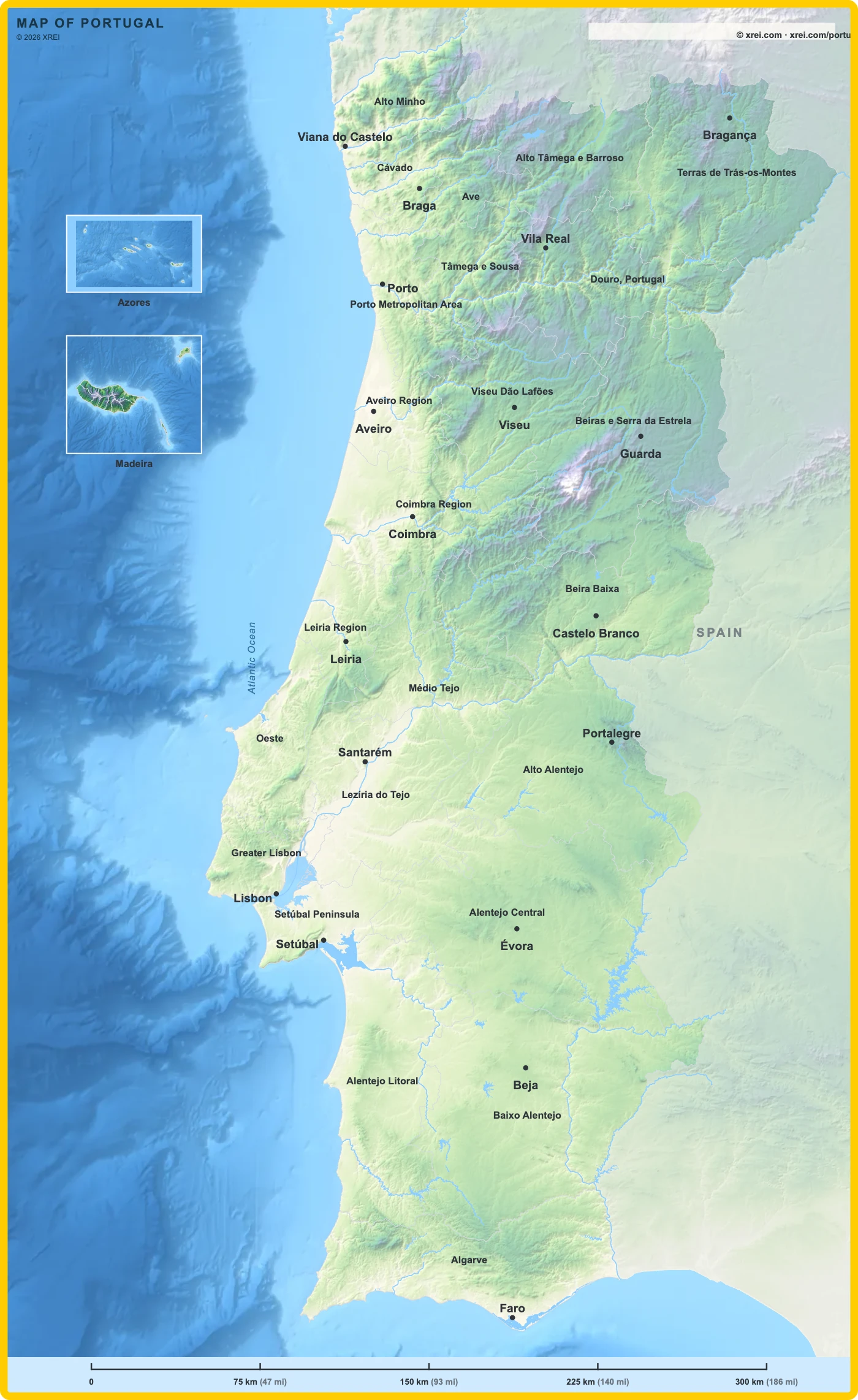
This map also sits at the bottom of the Portugal article. Click any area to go deeper into each place, parish, municipality or district. Share it with people who care about Portugal.

Map drawing by Jhose.com. Boundaries from CAOP, DGT Portugal. Reuse of this drawing requires attribution to xrei.com.Alto MinhoCávadoAvePorto Metropolitan AreaAlto Tâmega e BarrosoTâmega e SousaDouro, PortugalTerras de Trás-os-MontesAlgarveAveiro RegionCoimbra RegionLeiria RegionViseu Dão LafõesBeira BaixaBeiras e Serra da EstrelaGreater LisbonSetúbal PeninsulaAlentejo LitoralBaixo AlentejoAlto AlentejoAlentejo CentralOesteMédio TejoLezíria do TejoAlto MinhoCávadoAvePorto Metropolitan AreaAlto Tâmega e BarrosoTâmega e SousaDouro, PortugalTerras de Trás-os-MontesAlgarveAveiro RegionCoimbra RegionLeiria RegionViseu Dão LafõesBeira BaixaBeiras e Serra da EstrelaGreater LisbonSetúbal PeninsulaAlentejo LitoralBaixo AlentejoAlto AlentejoAlentejo CentralOesteMédio TejoLezíria do TejoAlto MinhoCávadoAvePorto Metropolitan AreaAlto Tâmega e BarrosoTâmega e SousaDouro, PortugalTerras de Trás-os-MontesAlgarveAveiro RegionCoimbra RegionLeiria RegionViseu Dão LafõesBeira BaixaBeiras e Serra da EstrelaGreater LisbonSetúbal PeninsulaAlentejo LitoralBaixo AlentejoAlto AlentejoAlentejo CentralOesteMédio TejoLezíria do TejoAveiroAveiroBejaBejaBragaBragaBragançaBragançaCastelo BrancoCastelo BrancoCoimbraCoimbraÉvoraÉvoraFaroFaroGuardaGuardaLeiriaLeiriaLisbonLisbonPortalegrePortalegrePortoPortoSantarémSantarémSetúbalSetúbalViana do CasteloViana do CasteloVila RealVila RealViseuViseuAzoresAzoresMadeiraMadeira
075 km (47 mi)150 km (93 mi)225 km (140 mi)300 km (186 mi)

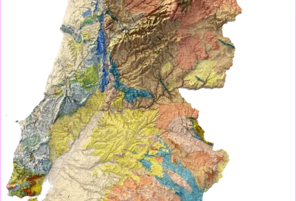
Carta Geológica de Portugal, 1:500 000, by J. F. N. Delgado and Paul Choffat, Direcção dos Trabalhos Geológicos, printed in Paris in 1899. The map won a gold medal at the Paris exposition of 1900. The original map is in the public domain. The relief shading in this version was added later by AI

What Portugal Is Made Of

The map paints every rock type a different colour. That is why Portugal looks striped. Each stripe is a different age and a different kind of ground. Below is a plain reading of the nine colours you see most.

Rock Where you see it What it means on the ground
Granite and syenite Minho, Trás-os-Montes, the Beiras, Serra da Estrela, the core of Serra de Sintra, Serra de Monchique Hard rock and strong ground. Soil is thin and acid. Wells depend on cracks in the rock, so one plot can give water and the next one nothing. National radon mapping links high radon susceptibility to granite and syenite ground. The reference level is 300 Bq/m³ and only a test in the building itself gives a real number. The rock of Monchique is nepheline syenite, called foyaite after the peak of Fóia, which is the place the rock is named from.
Basalt and volcanic rock Around Lisbon and Mafra, and around Sines Old lava flows, roughly 72 million years old. Basalt breaks down into dark, heavy, fertile clay. It is the reason the farmland north of Lisbon is so much richer than the sandy ground south of the river.
Old schist and greywacke Trás-os-Montes, the Douro valley, most of the Alentejo, the hills of the western Algarve The oldest rock on the map. It splits into flat slabs, which is why old walls and roofs in these regions are made of stone sheets. This is the ground the Douro and Alentejo vines grow in.
Quartzite and slate ridges Valongo, Serra do Buçaco, Portalegre, Marvão Narrow, very hard ridges that stand above everything around them. Good views and steep plots. Digging foundations or a pool here costs more than on soft ground. The same rock was quarried for roof slate.
Coal-bearing rock A thin band from Valongo to São Pedro da Cova and Pejão, east of Porto Portugal's coal came from this narrow strip. The mines are closed. The band is small, but it explains why an industrial mining history sits right next to Porto.
Jurassic limestone Serra de Aire e Candeeiros, Maciço de Sicó, Serra da Arrábida, the Algarve barrocal Rain slowly dissolves this rock. Water sinks in and travels underground instead of running in rivers, which is why these hills look dry on top and hold huge amounts of water below. The Maciço Calcário Estremenho is one of the largest groundwater stores in the country, with more than 1500 known caves and strong springs such as Olhos de Água and Alviela. It is also the source of Lioz, the stone used across Lisbon buildings and pavements.
Cretaceous limestone, sandstone and clay The Oeste, from Leiria down to Lisbon, and around Torres Vedras Mixed layers with a lot of clay. Clay swells when it is wet and shrinks when it is dry, so ground movement between seasons is normal here. A soil study before building is worth the money.
Miocene and Pliocene sands and clays Lezíria do Tejo, the Setúbal peninsula, Comporta, Grândola, the Algarve coastal strip Young and soft. These are the sandy soils under the pine and cork landscape of Comporta and Grândola. Easy to dig, but the ground carries less weight than rock.
Recent sand, dunes and river mud Ria de Aveiro, Ria Formosa, the Tagus flood plain, every beach and river mouth The youngest and softest ground in the country, and the lowest. Most land in the national flood maps sits on it. Soft ground also shakes more in an earthquake than rock does, which is why building rules class ground from rock to soft sediment and ask for a stronger design on the soft classes.

The map is shown with modern relief shading, so the same rock looks lighter on a sunlit slope and darker in a valley. The squares above use the true colour taken from the map's own legend panel.

Note on names. Delgado and Choffat used the words of their time. Arcaico is now called Precambrian, and Gotlandiano is now called Silurian. The map also marks things most geological maps leave out, including caves with animal bones, prehistoric settlement sites, mineral springs and working quarries. Delgado dug in those caves himself.

Sources

Portugal Map related places

We're Close to You

XREI operates from offices across Portugal — from Porto to the Algarve.

North

Porto — Edifício ICON

Rua Direita de Francos, 165 Piso 1 · 4100-211 Porto

Greater Lisbon

Lisboa — Rua Castilho

Rua Castilho, 39 · 1250-068 Lisboa

Greater Lisbon

Estoril

Avenida Aida, 353A · 2765-187 Estoril

Alentejo Coast

Comporta

Av. 18 Dezembro, 37 · 7570-779 Carvalhal

Algarve

Vilamoura — Marina Plaza

Av. da Marina, 3 · Marina Plaza Loja 14/15 · 8125-401 Quarteira