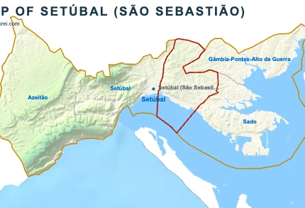
Setúbal is the capital of the Setúbal district and a municipality on the north bank of the Sado estuary (123 496 inhabitants · 230 km²), about 50 kilometres south of Lisbon, between the Serra da Arrábida and the river. The municipality includes the city, part of the Arrábida Natural Park and the wine villages of Azeitão.
The history of Setúbal has its own page.

Beaches in Setúbal
Setúbal has five beaches on the national bathing-water register, at the foot of the Serra da Arrábida between Albarquel and Portinho da Arrábida.
Figueirinha beach
- LocationSetúbal
- Beach typeOcean beach
Albarquel beach
- LocationSetúbal
- Beach typeOcean beach
Galapos beach
- LocationSetúbal
- Beach typeOcean beach
Galapinhos beach
- LocationSetúbal
- Beach typeOcean beach
Portinho da Arrábida beach
- LocationSetúbal
- Beach typeOcean beach
Monuments in Setúbal
- Convent of Jesus: a convent founded in 1490, whose church by Diogo de Boitaca is one of the first buildings in the Manueline style.
- Fortress of São Filipe: a star-shaped fortress begun in 1582 on a hill above the mouth of the Sado, with a chapel lined in tiles of 1736.
- Convent of Arrábida: a Franciscan convent founded in 1542 on the southern slope of the Serra da Arrábida.
- Church of São Julião: the church on Praça de Bocage, next to the city hall and the statue of the poet Bocage.
- Church of Santa Maria da Graça: the cathedral of the Diocese of Setúbal, created in 1975.
Museums and culture in Setúbal
- Museu de Arqueologia e Etnografia do Distrito de Setúbal: the archaeology and ethnography museum of the district, on Avenida Luísa Todi.
- Museu do Trabalho Michel Giacometti: a museum of work and industry in the city, named after the ethnographer Michel Giacometti.
- Casa da Baía: the tourism and promotion centre of the Bay of Setúbal, on Avenida Luísa Todi.
Markets in Setúbal
- Livramento Market: the central fresh-food market, opened in 1930, with about 5,700 tiles of the fishing and farming life of the city.
Nature in Setúbal
- Arrábida Natural Park: the protected area of the Serra da Arrábida and its coast, created in 1976, shared with Palmela and Sesimbra.
- Sado Estuary Nature Reserve: a protected wetland of 23,160 hectares, home to the only resident community of bottlenose dolphins in Portuguese waters.
Golf in Setúbal
Montado Golf Course
- LocationMontado Resort
- Course classChampionship
- Holes18
- Par72
- Length6 366 m
6 962 yd
Leisure in Setúbal
- Wine: the wine houses of Azeitão produce Moscatel de Setúbal and open their cellars to visitors.
- Dolphins, ferries and food: boat trips to watch the Sado dolphins and the ferry to Tróia leave from the riverfront. Visiting Setúbal covers transport, food and wine.
Marinas in Setúbal
- Doca de Recreio das Fontainhas: the leisure boat dock on the Setúbal riverfront.
- Porto de Setúbal: the commercial port of Setúbal, on the north bank of the Sado estuary.
Parishes of Setúbal
- Azeitão (20 946 inhabitants · 69 km²): the largest parish of the municipality by area, on the northern slope of the Serra da Arrábida.
- Gâmbia-Pontes-Alto da Guerra (6 809 inhabitants · 33 km²): a parish north-east of the city, home to the Montado golf course.
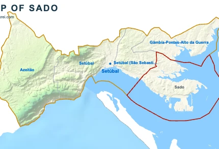
- Sado (5 357 inhabitants · 65 km²): a parish along the north bank of the Sado estuary, east of the city.
- São Julião, Nossa Senhora da Anunciada e Santa Maria da Graça (37 757 inhabitants · 37 km²): the parish of the historic centre of the city.
- São Sebastião (52 627 inhabitants · 26 km²): the most populous parish of the municipality.
Healthcare in Setúbal
Hospital da Luz Setúbal
- LocationSetúbal
- SectorPrivate
- KindGeneral hospital
- Emergency24-hour emergency
- Run byLuz Saúde
Hospital de São Bernardo
- LocationSetúbal
- SectorPublic
- KindGeneral hospital
- Emergency24-hour emergency
- Run byULS da Arrábida
Hospital Ortopédico de Santiago do Outao
- LocationSetúbal
- SectorPublic
- KindSpecialist hospital
- Run byULS da Arrábida
Hospital Nossa Senhora da Arrábida
- LocationSetúbal
- SectorPrivate
- KindSpecialist hospital
- Run byORPEA
Guides to Setúbal
You're reading Setúbal, Portugal article
Setúbal, Portugal
Arrábida & Setúbal
Arrábida & Setúbal

Azeitão
Convent of Jesus
Convent of Jesus
Fortress of São Filipe
Fortress of São Filipe
Convent of Arrábida
Convent of Arrábida
Livramento Market
Livramento Market
Sado Estuary Nature Reserve
Sado Estuary Nature Reserve
History of Setúbal
History of Setúbal
Visiting Setúbal