XREI page dedicated to all maps of Portugal. Not all maps are listed here yet, but we add more as time allows. Bookmark this page if you want to learn about Portugal, because we are constantly building new features. From here you can also visit the Homes for sale in Portugal page, updated several times per week, and the Real Estate Developments in Portugal page.
Interactive Map of Portugal
This map also sits at the bottom of the Portugal article. Click any area to go deeper into each place, parish, municipality or district. Share it with people who care about Portugal.
How High Portugal Is
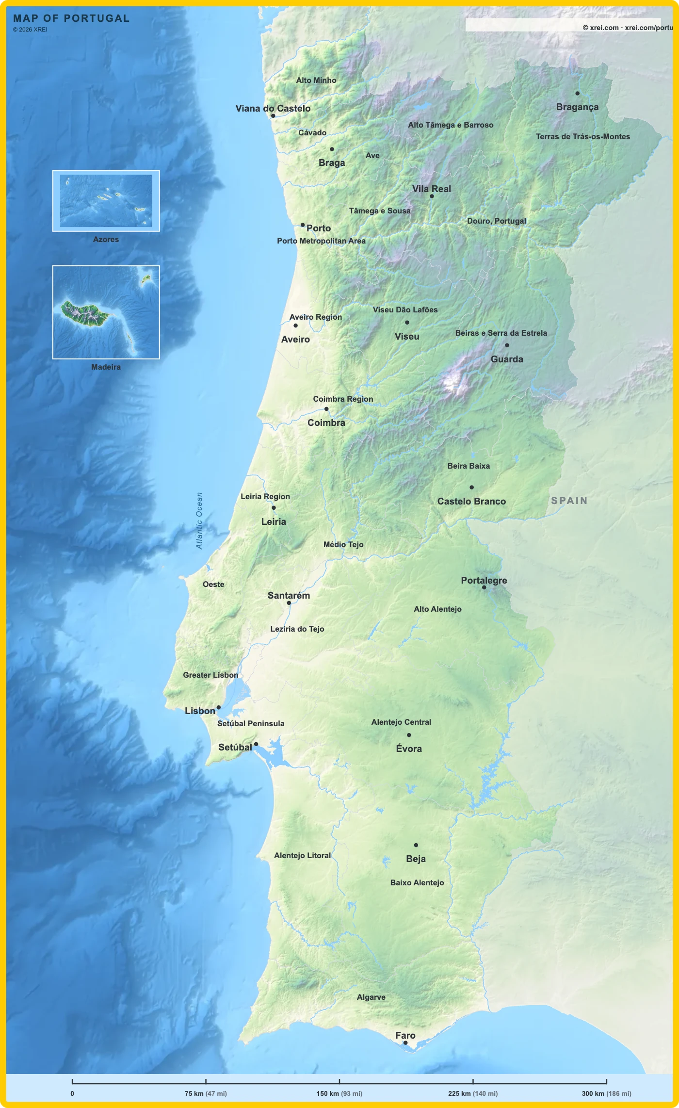
Each colour on the map is one height band, from cream at sea level to lilac on the highest ranges and white above 1750 m. The table lists the districts where each band covers the most ground, and the highest named points inside it.
| Height | Districts | Places and peaks |
|---|---|---|
| 0 to 80 m | Coastal strip of Viana do Castelo, Braga, Porto, Aveiro, Coimbra, Leiria, Lisboa, Setúbal, Faro, and the Tagus valley in Santarém | Ria de Aveiro, Lezíria do Tejo, Tagus and Sado estuaries, Ria Formosa |
| 80 to 200 m | Setúbal, Santarém, Lisboa, Leiria, Aveiro | Coastal plains of the centre, the lower Tagus and Sado basins |
| 200 to 400 m | Beja, Évora, Portalegre, Faro | The Alentejo plain, the Algarve barrocal |
| 400 to 650 m | Castelo Branco, Viseu, Coimbra, Portalegre | Beira Baixa plateau, the foothills of the central ranges |
| 650 to 950 m | Bragança, Vila Real, Viseu, Guarda, and Faro in one range | Trás-os-Montes plateau, Serra de Monchique (Fóia, 902 m) |
| 950 to 1300 m | Guarda, Coimbra, Castelo Branco, Portalegre | Guarda city (about 1056 m, the highest city in Portugal), Serra da Lousã (1205 m), Serra de São Mamede (1025 m) |
| 1300 to 1600 m | Braga, Viana do Castelo, Vila Real, Viseu, Bragança | Peneda-Gerês (Nevosa, 1545 m), Serra do Marão (1415 m), Serra de Montemuro (1382 m), Montesinho |
| 1600 to 1750 m | Guarda, Castelo Branco | Upper plateau of Serra da Estrela |
| Above 1750 m | Guarda, Castelo Branco, Madeira, Azores | Torre in Serra da Estrela (1993 m, highest point of the mainland), Pico Ruivo (1862 m), Mount Pico (2351 m, highest point of Portugal) |
Heights are averaged over 200 m squares on the mainland, so peaks read slightly lower on the map than their measured height. Shading comes from light placed in the north-west, so the same height looks lighter on a sunlit slope and darker in a valley. The squares above show the flat colour of each band.
Sources
- Heights: Copernicus DEM GLO-90 and GLO-30, © DLR e.V. 2010-2014 and © Airbus Defence and Space GmbH 2014-2018, provided under COPERNICUS by the European Union and ESA, all rights reserved.
- District boundaries: CAOP, Direção-Geral do Território, licence CC BY 4.0.
Other Maps of Portugal