Vila Real de Santo António is a border city on the Rio Guadiana, with 18 824 inhabitants across 61 km², founded in 1774 by the Marquis of Pombal on a grid plan.
A long waterfront avenue with historic buildings faces the river and the Spanish town of Ayamonte. Shopping streets lead from the river to the main square.
Beaches in Vila Real de Santo António
Monuments in Vila Real de Santo António
Praça Marquês de Pombal : main square in Pombaline style, with the Igreja Matriz, an obelisk in honour of King José I and turrets at its four corners.Farol de Vila Real de Santo António : working lighthouse with a round tower, open to visitors.
Museums and culture in Vila Real de Santo António
Arquivo Histórico Municipal António Rosa Mendes : historical documents on the region.Centro Cultural António Aleixo : cultural centre hosting regional performances.
Markets in Vila Real de Santo António
Mercado Municipal : traditional market by the river.
Nature and leisure in Vila Real de Santo António
Mata Nacional das Dunas de Vila Real de Santo António : pine forest on the dunes behind the beaches.Adventure Park : tree-top activity park in the dune forest.Casino de Monte Gordo : gaming rooms and an entertainment programme.
Marinas in Vila Real de Santo António
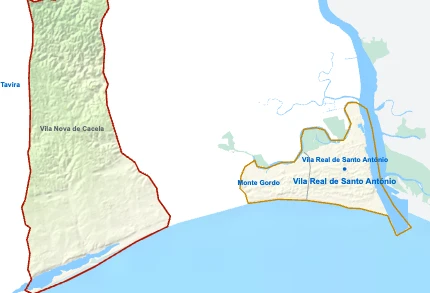
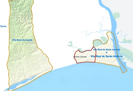
Parishes of Vila Real de Santo António
Monte Gordo Vila Nova de Cacela
Places to visit in the Algarve
Parishes of Vila Real de Santo António map Vila Real de Santo António is a Municipality and a Parish of Algarve in Portugal in the continent of Europe .
Copy link or Share
Spain Albufeira Alcoutim Aljezur Castro Marim Faro Lagoa Lagos Loulé Monchique Olhão Portimão São Brás de Alportel Silves Tavira Vila do Bispo Vila Nova de Cacela Vila Real de Santo António Monte Gordo Albufeira Alcoutim Aljezur Castro Marim Faro Lagoa Lagos Loulé Monchique Olhão Portimão São Brás de Alportel Silves Tavira Vila do Bispo Vila Nova de Cacela Monte Gordo Río Guadiana / Rio Guadiana Dique Estero de la Rivera Salina Estero de Canela Ribeira de Odeleite Ribeira do Beliche Ribeira de Rio Seco Ribeira da Gafa Ribeira da Caldeira Barranco do Lobo Barranco das Pereiras Barranco do Moiro Ribeira da Caroucha Barranco da Água de Todo o Ano Barranco dos Negros Ribeira de Cacela Ribeira da Zambujosa (ou Zambusa ) Barranco dos Casarões Barranco do Ribeiro Ribeira do Álamo Ribeira da Galharda Barranco do Rosado Nao Barranco da Bornacha Albufeira da Barragem da Caroucha Barragem do Vitalino Estero de la Rivera Estero de San Bruno Esteiro Esteiro da Leziria Esteiro Esteiro da Lezíria Esteiro da Leziria Esteiro da Carrasqueira Decantador Estero de Canela Estufas de Crescimento de Pescado Estufas de Crescimento de Pescado Albufeira de Beliche Ria Formosa Barragem de Beliche Barragem da Caroucha Castro Marim Tavira Vila Nova de Cacela Vila Real de Santo António Monte Gordo Ribeira do Álamo Vila Real de Santo António Vila Real de Santo António xrei.com MAP OF VILA REAL DE SANTO ANTÓNIO © 2026 xrei.com
0 4 km (2.5 mi) 8 km (5 mi) 12 km (7.5 mi) 16 km (9.9 mi)
Height
0 80 200 247 m
0 262 656 810 ft
0 m (0 ft), 80 m (262 ft), 200 m (656 ft), Max altitude 247 m (810 ft) Sea depth
0 150 600 1 800 3 200 5 200+ m
0 492 1 970 5 910 10 500 17 060+ ft
0 m (0 ft), 150 m (492 ft), 600 m (1970 ft), 1800 m (5910 ft), 3200 m (10500 ft), deeper than 5200 m (17060 ft) Height from west to east in Vila Real de Santo António
0 m 80 m 200 m 400 m xrei.com 247 m 0 m West 16.1 km East
Height from south to north in Vila Real de Santo António
0 m 80 m 200 m 400 m xrei.com 1 2 247 m 0 m South 13.0 km North 1 Sea 0 m 2 Rio Guadiana 0 m
Informação geográfica cedida pela Direção-Geral do Território (CAOP, CC BY 4.0) · © OpenStreetMap contributors (ODbL) · GEBCO 2026 Grid · Heights: NASADEM, NASA
Portugal Map Regions and Districts of Portugal Algarve Vila Real de Santo António (you are here) Portugal map Homes map 2183 Developments map 186
Basic Information Vila Real de Santo António population (data from last censos): Municipality has 18 824 Inhabitants11 754 Inhabitants
Vila Real de Santo António area: Municipality has 61 km² / 24 sq mi11 km² / 4 sq mi
Where is Vila Real de Santo António located in Portugal? Show map 🗺
Parishes of Vila Real de Santo António Vila Real de Santo AntónioYou’re reading this article Parish population 11 754 inhabitants Parish area 11 km² Parish population 3 873 inhabitants Parish area 46 km² Parish population 3 197 inhabitants Parish area 4 km² Municipalities of Algarve Municipality population 72 332 inhabitants Municipality area 764 km² Municipality population 67 622 inhabitants Municipality area 203 km² Municipality population 59 845 inhabitants Municipality area 182 km² Municipality population 44 614 inhabitants Municipality area 131 km² Municipality population 44 164 inhabitants Municipality area 141 km² Municipality population 37 766 inhabitants Municipality area 680 km² Municipality population 33 494 inhabitants Municipality area 213 km² Municipality population 27 523 inhabitants Municipality area 607 km² Municipality population 23 725 inhabitants Municipality area 88 km² Vila Real de Santo AntónioYou’re reading this article Municipality population 18 824 inhabitants Municipality area 61 km² Municipality population 11 248 inhabitants Municipality area 153 km² Municipality population 6 439 inhabitants Municipality area 301 km² Municipality population 6 045 inhabitants Municipality area 324 km² Municipality population 5 717 inhabitants Municipality area 179 km² Municipality population 5 462 inhabitants Municipality area 395 km² Municipality population 2 523 inhabitants Municipality area 575 km²