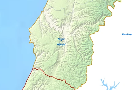
Aljezur

Aljezur

Aljezur is a town between the sea and the hills of the western Algarve, with 6 045 inhabitants across 324 km², known for its natural landscapes and its historical and cultural heritage.

The whole coast of the municipality lies within the Parque Natural do Sudoeste Alentejano e Costa Vicentina, a protected area of more than 100 kilometres between Porto Covo, in the Alentejo, and Burgau, in the Algarve. The park has plant and animal species found nowhere else, and coloured, steep cliffs above beaches with conditions for surfing. The coast faces the open Atlantic, with more wind and swell than the south coast of the Algarve, and is less built-up because it lies inside the park.

Beaches in Aljezur

  • Praia da Arrifana: beach in a cove sheltered from the north wind, with the Pedra da Agulha, a rock needle, offshore.
  • Praia de Monte Clérigo: wide beach beside a small summer village, with a rock platform exposed at low tide.
  • Praia da Amoreira: beach at the mouth of a green river valley.
  • Praia da Carriagem: beach with rocks reaching into the sea.
  • Praia do Vale dos Homens: beach below high cliffs.
  • Praia da Samouqueira: beach with a cave that can be walked through at low tide.
  • Praia das Adegas: naturist beach.
  • Praia de Odeceixe: beach between dark cliffs at the northern border of the Algarve.
  • Praia da Bordeira: long beach where the Ribeira da Carrapateira meets the sea.
  • Praia do Amado: wide beach with parking and services, popular with surf schools and families.

Monuments in Aljezur

  • Castelo de Aljezur: castle of Islamic origin on the hill above the town, taken by Christian forces in the 13th century.
  • Igreja Matriz de Aljezur: 18th-century Baroque and Neoclassical church with a white facade and bell tower, holding the image of Nossa Senhora da Alva, the local patron saint.
  • Fortaleza da Arrifana: fort on the cliff above Praia da Arrifana.
  • Ribat da Arrifana: remains of a Muslim fortified religious retreat on the headland of Ponta da Atalaia, of high archaeological value.

Museums and culture in Aljezur

  • Museu do Mar e da Terra da Carrapateira: the role of the sea and the land in local customs and economy.

Gastronomy of Aljezur

The farming village of Rogil is known for its sweet potato.

Walking in Aljezur

Both long-distance routes of the Rota Vicentina cross Aljezur. South of Arrifana, the coastal path crosses an almost untouched landscape of dunes, heather, thistles and aromatic shrubs.

  • Fishermen's Trail (Trilho dos Pescadores): coastal stages from Aljezur to Arrifana and from Arrifana to Carrapateira, part of a route of about 226 km from Porto Covo to Lagos.
  • Historical Way (Caminho Histórico): rural stages from Odeceixe to Aljezur, Aljezur to Arrifana and Arrifana to Carrapateira, part of a 263 km route certified as a "Leading Quality Trail – Best of Europe" in 2016 and 2020.
  • Circular routes: shorter walks from villages and beaches, including Odeceixe to the sea, Odeceixe to the river, Amoreira, Amado, the Carrapateira hills and from Bordeira to the sea.

Parishes of Aljezur

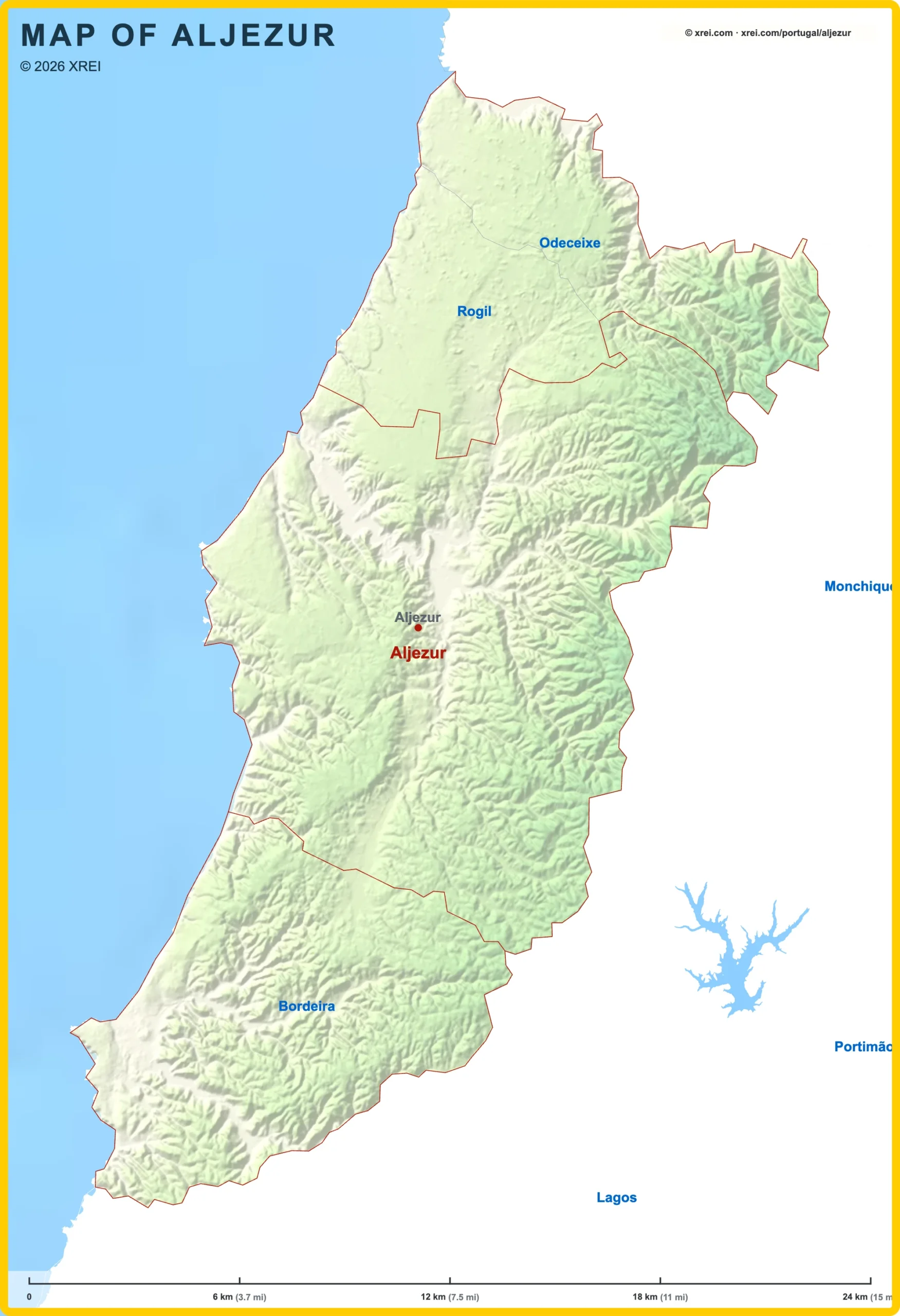
  • Odeceixe (1 055 inhabitants · 42 km²): northern parish on the border with the Alentejo.
  • Rogil (1 165 inhabitants · 35 km²): parish north of the town.
  • Bordeira (370 inhabitants · 80 km²): southern parish with the village of Carrapateira.

Schools in Aljezur

Places to visit in the Algarve

Barlavento, the windward Algarve

Golden Triangle

Sotavento, the leeward Algarve

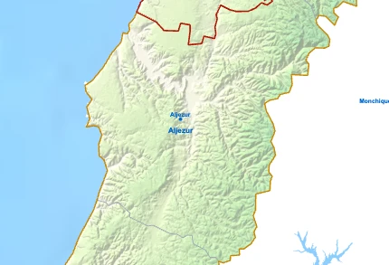
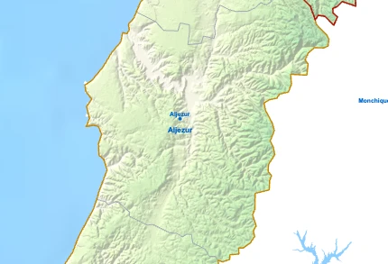
Parishes of Aljezur map

Aljezur is a Municipality and a Parish of Algarve in Portugal in the continent of Europe.

Map drawing by Jhose.com. Reuse of this drawing requires attribution to xrei.com. Sources used on xrei maps (each map names its own under it): Informação geográfica cedida pela Direção-Geral do Território (CAOP, CC BY 4.0) | © OpenStreetMap contributors (ODbL) | GEBCO 2026 Grid | Heights: NASADEM, NASASpainOdemiraAlbufeiraAlcoutimCastro MarimFaroLagoaLagosLouléMonchiqueOlhãoPortimãoSão Brás de AlportelSilvesTaviraVila do BispoVila Real de Santo AntónioAljezurBordeiraOdeceixeRogilOdemiraAlbufeiraAlcoutimCastro MarimFaroLagoaLagosLouléMonchiqueOlhãoPortimãoSão Brás de AlportelSilvesTaviraVila do BispoVila Real de Santo AntónioBordeiraOdeceixeRogilRio MiraRio SeixeRibeira de AljezurRibeira de OdiáxereRibeira da CercaRibeira de BensafrimRibeira de SeixeRibeira do ArroioRibeira do ArãoRibeira de Vale BarãoBarranco da AzenhaRibeira do LameiroRibeira das AlfambrasRibeira do Monte NovoRibeira do CerradoBarranco do CarvalhalRibeira de AlmádenaRibeira do ArieiroRibeira da SurreiraBarranco da GaléRibeira da VagarosaBarranco da AmeijoafraRibeira da SobrosaRibeira das Águas AlvasBarranco do RouchãoRibeira da CarrapateiraBarranco do Olho PusanesRibeira da AmieiraRio dos QuteirosBarranco das VoltasRibeira da BordeiraBarranco do SobralinhoRibeira da PernaRibeira do TacualBarranco do CarrascalinhoBarranco de Vale FrancelheBarranco Corte CabreiraBarranco dos MartinhaisBarranco da Foz das ÁguasBarranco da MedronhaRibeira SecaBarranco do AzevinhoBarranco do Vale das MoçasBarranco do ChaparralBarranco do Vale da MudaBarranco de Maria VinagreRibeira da MachadaRibeiro do Vale das CovasBarranco do Vale de FechoRibeiro da AssumadaBarranco do CiceiroBarranco de Água de PeixeBarranco das CachopasBarranco do Monte ClérigoBarranco do CorsinoVale das AmoreirasBarranco da CasotaRibeiro de EspicheRibeira das CobrasRibeiro de Entre ÁguasRibeira dos MorenosRibeira do Barranco de Porto de MósRibeira do ParaísoBarranco do LavradioAlbufeira de Vale da TelhaAquiculturaLagoa do RuazMarina de LagosAlbufeira de OdeáxereGolf PondRia de AlvorCâmara de Dissipação de Energia da Barragem de OdiáxereBacia de dissipaçãoBarragem de OdeáxereBarragem de Vale da TelhaOdemiraLagosMonchiquePortimãoVila do BispoAljezurBordeiraOdeceixeRogilRibeira do ArieiroRibeira da VagarosaAljezurAljezurxrei.comMAP OF ALJEZUR© 2026 xrei.com
06 km (3.7 mi)12 km (7.5 mi)18 km (11 mi)24 km (15 mi)
Height
0 m (0 ft), 80 m (262 ft), 200 m (656 ft), Max altitude 369 m (1210 ft)
Sea depth
0 m (0 ft), 150 m (492 ft), 600 m (1970 ft), 1800 m (5910 ft), 3200 m (10500 ft), deeper than 5200 m (17060 ft)
Height from west to east in Aljezur
0 m80 m200 m400 mxrei.com369 m0 mWest21.7 kmEast
Height from south to north in Aljezur
0 m80 m200 m400 mxrei.com1369 m0 mSouth32.4 kmNorth
1Sea0 m

Informação geográfica cedida pela Direção-Geral do Território (CAOP, CC BY 4.0) · © OpenStreetMap contributors (ODbL) · GEBCO 2026 Grid · Heights: NASADEM, NASA

Basic Information

Aljezur population (data from last censos): Municipality has 6 045 Inhabitants
Parish has 3 455 Inhabitants

Aljezur area: Municipality has 324 km² / 125 sq mi
Parish has 167 km² / 64 sq mi

Where is Aljezur located in Portugal?

Parishes of Aljezur

Aljezur

AljezurYou’re reading this article

  • Parish population⁨3 455 inhabitants⁩
  • Parish area⁨167 km²
    64 sq mi
    ⁩
Rogil

Rogil

  • Parish population⁨1 165 inhabitants⁩
  • Parish area⁨35 km²
    13 sq mi
    ⁩
Odeceixe

Odeceixe

  • Parish population⁨1 055 inhabitants⁩
  • Parish area⁨42 km²
    16 sq mi
    ⁩
Bordeira

Bordeira

  • Parish population⁨370 inhabitants⁩
  • Parish area⁨80 km²
    31 sq mi
    ⁩

Municipalities of Algarve

Loulé

Loulé

  • Municipality population⁨72 332 inhabitants⁩
  • Municipality area⁨764 km²
    295 sq mi
    ⁩
Faro

Faro

  • Municipality population⁨67 622 inhabitants⁩
  • Municipality area⁨203 km²
    78 sq mi
    ⁩
Portimão

Portimão

  • Municipality population⁨59 845 inhabitants⁩
  • Municipality area⁨182 km²
    70 sq mi
    ⁩
Olhão

Olhão

  • Municipality population⁨44 614 inhabitants⁩
  • Municipality area⁨131 km²
    51 sq mi
    ⁩
Albufeira

Albufeira

  • Municipality population⁨44 164 inhabitants⁩
  • Municipality area⁨141 km²
    54 sq mi
    ⁩
Silves

Silves

  • Municipality population⁨37 766 inhabitants⁩
  • Municipality area⁨680 km²
    263 sq mi
    ⁩
Lagos

Lagos

  • Municipality population⁨33 494 inhabitants⁩
  • Municipality area⁨213 km²
    82 sq mi
    ⁩
Tavira

Tavira

  • Municipality population⁨27 523 inhabitants⁩
  • Municipality area⁨607 km²
    234 sq mi
    ⁩
Lagoa

Lagoa

  • Municipality population⁨23 725 inhabitants⁩
  • Municipality area⁨88 km²
    34 sq mi
    ⁩
Vila Real de Santo António

Vila Real de Santo António

  • Municipality population⁨18 824 inhabitants⁩
  • Municipality area⁨61 km²
    24 sq mi
    ⁩
São Brás de Alportel

São Brás de Alportel

  • Municipality population⁨11 248 inhabitants⁩
  • Municipality area⁨153 km²
    59 sq mi
    ⁩
Castro Marim

Castro Marim

  • Municipality population⁨6 439 inhabitants⁩
  • Municipality area⁨301 km²
    116 sq mi
    ⁩
Aljezur

AljezurYou’re reading this article

  • Municipality population⁨6 045 inhabitants⁩
  • Municipality area⁨324 km²
    125 sq mi
    ⁩
Vila do Bispo

Vila do Bispo

  • Municipality population⁨5 717 inhabitants⁩
  • Municipality area⁨179 km²
    69 sq mi
    ⁩
Monchique

Monchique

  • Municipality population⁨5 462 inhabitants⁩
  • Municipality area⁨395 km²
    153 sq mi
    ⁩
Alcoutim

Alcoutim

  • Municipality population⁨2 523 inhabitants⁩
  • Municipality area⁨575 km²
    222 sq mi
    ⁩

Aljezur for buyers and investors

Browse homes for sale and new developments in this area and nearby. Our team can guide you from search to purchase. Contact us.

We're Close to You

XREI operates from offices across Portugal — from Porto to the Algarve.

North

Porto — Edifício ICON

Rua Direita de Francos, 165 Piso 1 · 4100-211 Porto

Greater Lisbon

Lisboa — Rua Castilho

Rua Castilho, 39 · 1250-068 Lisboa

Greater Lisbon

Estoril

Avenida Aida, 353A · 2765-187 Estoril

Alentejo Coast

Comporta

Av. 18 Dezembro, 37 · 7570-779 Carvalhal

Algarve

Vilamoura — Marina Plaza

Av. da Marina, 3 · Marina Plaza Loja 14/15 · 8125-401 Quarteira