
Beja
The city of Beja is an ancient city located in the Baixo Alentejo, with a traditional agricultural culture, landscapes defined by farmland, and streets and squares bearing strongly historical and ecclesiastical character. In Beja we find a great diversity of attractions: a city surrounded by countryside, with castles and museums, natural parks and religious buildings. It is a city where historical memory is very much present in the churches, convents and monuments that characterise the Beja landscape. The ancient character of this Alentejo city intersects with the legacy of other peoples, such as the Moors and the Visigoths, who influenced the culture and customs of Beja — a legacy also reflected in the city’s coat of arms, where a bull symbolises an ancient narrative. Legend has it that a fearsome serpent terrorised the inhabitants of Beja, prompting the population to place a poisoned bull in the forest in order to rid themselves of the creature. It is tales and myths of this kind that lend a mysterious quality to the Beja region, and fire the imagination of all who visit the city. Beja is the hottest district capital in the country, with mild winters and long, hot summers.
Attractions to visit in the city of Beja
The historic centre of the city of Beja:
Praça da República: is the heart of Beja, the political and administrative centre of the city. It was in this square that festivals, bullfights and theatrical performances took place during the Middle Ages and the Age of Discoveries. The Praça da República features buildings such as the Igreja da Misericórdia, the headquarters of the Conservatório Regional do Baixo Alentejo installed in a 16th-century palace, the Tax Office in a 17th-century palace, the former city jail and the Câmara Municipal inaugurated in 1953. The Largo de Santo Amaro, the site of the agrarian reform market following 25 April 1974, deserves mention for the Igreja de Santo Amaro, where we find the Visigothic Nucleus of the Museu Regional de Beja. The Largo de São João, the most recent area of the historic centre, has as its main attractions the centuries-old Clube Bejense, the Cine-Teatro Pax Julia inaugurated in 1928, a sculpture by Noémia Cruz in the centre of the square, and the Travessa do Cepo, which forms part of the medieval city of Beja, notable for its Gothic arch. Rua do Sembrano, notable for the Archaeological Nucleus of Rua do Sembrano, which includes Iron Age walls, the ruins of Roman baths and modern tile panels on the theme of water by the painter Rogério Ribeiro. And Praça Diogo Fernandes, notable for the Jardim do Bacalhau, where we find a modern iron sculpture by Jorge Vieira dedicated to the Unknown Political Prisoner.
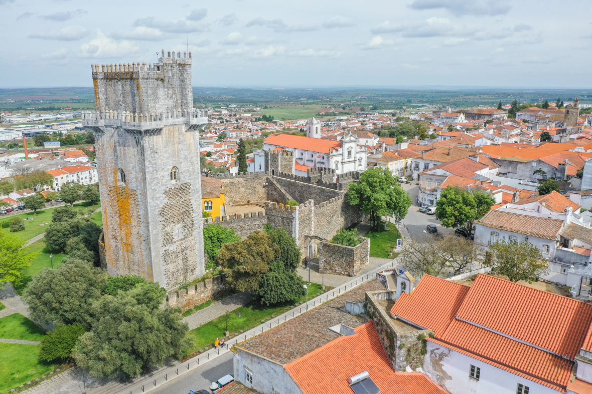
Castelo de Beja
Castelo de Beja: is the most popular and emblematic monument in Beja, a well-maintained medieval castle located in the city centre, with walls encircling the old town. The Castelo de Beja is renowned for possessing the tallest keep in the Iberian Peninsula, standing at nearly 40 metres, and a remarkable vault with an eight-pointed star. The castle has an imposing presence thanks to its tower and to the architectural features of the Manueline, Gothic, Mannerist and Romanesque styles. It is a monument directly linked to the history of Portugal, where visitors can explore the Casa do Governador, the magnificent keep, and walk the perimeter of the walls that surround the old town, enjoying a privileged panoramic view over Beja and its surroundings. The ancient enclosure of the Castelo de Beja was composed of forty towers and four main gates: the Portas de Évora, the Portas de Mértola, the Portas de Avis and the Portas de Aljustrel. Over the centuries, three further gates were added to the walls: the Portas de Moura, the Portas de São Sisenando and the Portas da Corredoura. The Porta de Évora, also known as the Roman Arch of Beja, is the main entrance beside the castle. Inside the castle, since 2019, visitors will find the Jorge Vieira contemporary art museum.
Parque da Cidade de Beja
The Parque da Cidade is a typical leisure garden much frequented by the local population. Located to the west of the city of Beja, it was built in 2004 with a large lake at its centre, various gardens for recreational activities and utility services. Here we find a restaurant, terrace and kiosk, a children’s playground, a small half-pipe for skateboards and inline skates, a dedicated area for pets, and picnic tables and benches. There is also an area with sports equipment available to visitors. The Parque da Cidade de Beja stands out from the urban landscape thanks to its extensive green spaces, where a wide variety of plants can be found, including willows, poplars, fig trees and cork oaks typical of the Alentejo. This park provides an environmental benefit to the region through its green cover, and serves as a setting for activities as varied as ball games, walking, cycling, reading and yoga.
Attractions to visit in the district of Beja
Parque Natural do Sudoeste Alentejano e Costa Vicentina
Parque Natural do Sudoeste Alentejano e Costa Vicentina: is a natural park regarded as one of the most beautiful coastal areas in the world, with a coastal extension of over 100 km, bounded to the north by the Ribeira da Junqueira in São Torpes, in the district of Setúbal, and to the south by the beach of Burgau in the Algarve, district of Faro. The park is one of the gems of the Alentejo, owing to its great diversity of monuments, islets, wild beaches with Atlantic swell, limestone cliffs, protected vegetation, migratory birds, walking paths, small towns and villages, and many points of interest that attract thousands of visitors every year. The beaches with their extensive stretches of sand captivate surfing enthusiasts, while nature lovers visit the Parque Natural do Sudoeste Alentejano e Costa Vicentina to discover the Ponta de Sagres, where we find the Fortaleza de Sagres at Cabo de São Vicente. The appearance of the park undergoes radical changes from season to season, attracting visitors throughout the year. With dozens of beaches along the west and south coasts, the Parque Natural do Sudoeste Alentejano e Costa Vicentina is internationally known as a surfing destination, from São Torpes to Zavial on the south coast, passing through dozens of beaches — listed from north to south, the most well-known are: Praia da Samoqueira, Praia dos Buizinhos and Praia de Porto Covo in Porto Covo, Praia da Franquia and Praia das Furnas in Vila Nova de Milfontes, Praia do Almograve, Praia do Cavaleiro, Praia de Zambujeira do Mar, Praia da Amália, Praia das Adegas and Praia de Odeiceixe, Praia do Vale dos Homens, Praia da Carriagem, Praia da Amoreira at the mouth of the Ribeira de Aljezur, Praia de Monte Clérigo and Praia da Fateixa in Monte Clérigo, Praia do Medo da Fonte Santa, Praia da Arrifana in the village of Arrifana, Praia da Pedra Agulha, Praia do Canal, Praia de Vale Figueiras, Praia da Bordeira and Praia do Amado in the village of Carrapateira, Praia da Cordoama and Praia do Castelejo in Vila do Bispo; Praia da Ponta Ruíva in a location entirely surrounded by wild nature, and the beaches in the village of Sagres, namely Praia do Beliche, Praia do Tonel, Praia da Marteta and Praia do Martinhal. The main natural attractions of the Parque Natural do Sudoeste Alentejano e Costa Vicentina are:
- The cliffs and reefs at Ilha do Pessegueiro, Cabo Sardão, Carrapateira and Cabo de São Vicente;
- The fauna, with approximately 200 bird species, of which 26 nest on cliffs. Particular mention goes to the white stork (uniquely in the world nesting on sea rocks), the peregrine falcon, the fastest bird in the natural park, capable of reaching a diving speed of approximately 385 km/h;
- The flora, with approximately 750 plant species, of which 12 are found exclusively in this location;
- The restricted fishing river zones, namely the Ribeira do Seixe, Ribeira de Aljezur, Ribeira de Bordeira and the Rio Mira;
- The restricted fishing maritime zones, namely Pedras do Burrinho, da Atalaia, da Carraca, da Agulha, da Enseada do Santoleiro, da Baía da Nau, das Gaivotas, do Gigante, da Ilha do Pessegueiro, do Cabo Sardão, dos Ilhotes do Martinhal and the Rogil zone;
Parque Natural do Vale do Guadiana
The Parque Natural do Vale do Guadiana is a protected natural park created in 1995 to preserve the stretch of the Guadiana River around the town of Mértola. The park covers an area of plains, hills and valleys extending along the Guadiana Valley river basin, with extremely rich fauna and flora including protected Mediterranean vegetation sheltered from human intervention, with cliff-nesting birds throughout the territory. Here we find various hiking trails where birds can be observed, the park being an important corridor for migratory birds and habitat for birds of prey, and home to some species unique in the world, such as the Saramugo fish. In addition to all these natural attributes, visitors can explore various attractions in the Parque Natural do Vale do Guadiana, such as the Pulo do Lobo waterfall, the museum-village of Mértola with over a thousand years of history, the Castelo de Mértola, the Ermida de Nossa Senhora das Neves, the Igreja Matriz de Nossa Senhora da Anunciação, the Museu de Mértola – Núcleo da Basílica Paleocristã, the Ponte de Mértola, a centuries-old bridge over the Ribeira de Oeiras declared a National Monument, the Praia Fluvial Azenhas do Guadiana, the Praia Fluvial da Tapada Grande, and the Mina de São Domingos, an abandoned mining complex. The main natural attractions of the Parque Natural do Vale do Guadiana are:
- The Geosites, namely the Pulo do Lobo waterfall; the Stratigraphic Sequence of Pomarão with volcanic rocks of unique characteristics in the Iberian Peninsula, approximately 350 million years old; and the Mina de São Domingos, a mine exploited from the Roman period until 1962, which was rich in copper, sulphur, gold, lead and zinc;
- The Heritage comprising the Centro de Interpretação da Paisagem da Amendoeira, the Centro de Estudos e Sensibilização Ambiental do Monte do Vento, and the Praia Fluvial da Tapada Grande;
- And the Points of interest comprising the Moinho dos Canais, Rocha da Galé, Azenhas do Guadiana, Penha da Águia, Ribeira do Vascão, Antas das Pias, Azinhal (Crane Feeding Area), Monte da Balança with steppe birds and the Barragem dos Corvos.
Cascata do Pulo do Lobo
The Cascata do Pulo do Lobo is a waterfall located on the Guadiana River, accessible via the Herdade do Pulo do Lobo, characterised by the spectacular drop of crystal-clear waters from over 20 metres through narrow rocky gorges. The water falls into the river with great force, creating a spectacular waterfall effect. The Cascata do Pulo do Lobo has been referred to as one of Portugal’s natural wonders. The name of the waterfall originates from a legend which tells that a wolf managed to cross the narrow banks of the river in a single leap. The Pulo do Lobo is a place of strong telluric energy, with the sound of water, a misty atmosphere and the river current. There is a risk of falling for the inattentive, however the recommended viewing area is protected by a railing. The banks of the Cascata do Pulo do Lobo are rocky and steep, with the Guadiana River as a backdrop. To access the waterfall on the Portuguese bank, visitors should enter the Herdade do Pulo do Lobo, where a gate is located. At this point there is a notice indicating that the gate may be opened to enter, though visitors are asked to leave it closed after passing through.
Ilha do Pessegueiro, Forte da Ilha de Fora, Praia do Pessegueiro and Forte de Nossa Senhora da Queimada
Ilha do Pessegueiro: is a small island with no sandy beach, located south of Porto Covo, within the Parque Natural do Sudoeste Alentejano e Costa Vicentina. The only building on the island is the Forte de Santo Alberto do Pessegueiro, also known as the Forte da Ilha de Fora, whose original function was to provide crossfire with the Forte de Nossa Senhora da Queimada, classified as a National Monument, located beside the Praia da Ilha do Pessegueiro. It is a military defensive construction built on sandstone rock with a polygonal plan, reinforced by triangular bastions with battered walls, built in the 17th century to prevent the advance of pirates. The earthquake of 1755 caused significant damage to the complex of fortresses. Facing the island, on the mainland, we find Praia da Ilha do Pessegueiro, a beach of approximately 750 metres of sand and rock, west-facing, located 2 km south of Porto Covo, opposite the Porto Covo campsite. This island was immortalised in the song “Porto Covo” composed by Portuguese musician Rui Veloso.
Castelo de Mértola
Castelo de Mértola: is a castle erected in the 13th century by the knights of the Order of Santiago, located in the town of Mértola (district of Beja) in an elevated position overlooking the town and the Guadiana River. It is a Gothic-style castle that underwent various transformations and restorations over the centuries due to Roman and Arab occupation. The Castelo de Mértola includes a keep of approximately 30 metres, two smaller towers and a cistern in the centre of the parade ground. The castle benefited from repair works in the last century and the keep today serves as an exhibition space for archaeological discoveries from the Roman, Visigothic, Islamic and Portuguese periods. In addition to its historical attributes and excellent state of conservation, one of the most praised aspects of the Castelo de Mértola is the broad view over the town of Mértola and the Guadiana River from the top of the walls. From here, the other parishes can be seen. To the left of the Castelo de Mértola we find the parish church, a former mosque converted into a church after the Christian Reconquest.
Castelo de Moura
Castelo de Moura: is a 13th-century medieval construction located on the left bank of the Guadiana, the period when Moura was occupied by Christians for the first time. The Portuguese made use of the fortifications left by the Arabs to build and expand the castle as the population grew. The Castelo de Moura underwent various architectural changes over the years, the most notable being the construction of the Convento de Nossa Senhora da Assunção and the clock towers. Beyond the imposing nature of the monument and its location in the very heart of the city of Moura, the castle is an attraction owing to its rectangular Manueline-style plan and the Gothic style of the keep, with the Sala dos Alcaides featuring an octagonal plan covered by a ribbed ogival vault. The legend of the Moorish Princess Salúquia tells that the city of Moura was taken from the Moors due to a mistake by Princess Salúquia, who mistakenly confused the brothers of D. Afonso Henriques disguised in Muslim dress for Islamic knights, granting them entry to the castle. They defeated the Moors and conquered the fortress and town, renaming it “Terra da Moura Salúquia”, which gave rise to the name of the city of Moura.
Centro Ciência Viva do Lousal
The Centro de Ciência Viva do Lousal is a dynamic space for knowledge and leisure, whose main purpose is to promote scientific and technological culture among the public. The venue invites visitors on a journey through time, where they can explore a representation of the now-defunct Lousal mine, with thousands of miners depicted at full operation. Although the scientific focus and knowledge are central to the Centro Ciência Viva do Lousal, there is also space to address other topics of the era through interactive content dedicated to geology, physics, chemistry, mathematics, computer graphics and biology. The industrial museum that currently houses the Centro Ciência Viva do Lousal was a former mining complex from 1934 to 1992. Following adaptations, this facility now offers a virtual cave, rooms for content exhibitions, a laboratory, an auditorium, a cybercafé and a viewpoint. The Centro Ciência Viva is an excellent way for families to combine knowledge and entertainment in a single activity.
Museu Regional de Beja – Museu Rainha D. Leonor
The Museu Regional de Beja – Museu Rainha D. Leonor is one of the oldest museums in Portugal, created in 1917 and inaugurated in 1927. It is located in the former Convento da Conceição, in the parish of Santa Maria da Feira in the city of Beja. Also known as the Museu Rainha Dona Leonor, this space documents the different cultures present in the Alentejo from prehistory to the present day through an extensive collection, which originated from other convents and palaces in the region. The main collection features pieces of Roman archaeology found during the empire of Julius Caesar, revealing the occupation of this territory. The museum underwent several expansion and restoration works over the years, making it possible to concentrate in one location a combination of pieces in styles as diverse as Gothic, Manueline and Baroque. The beauty of the tilework, painting, sculpture and gilded woodwork found in its interior impresses visitors with its grandeur. From 1991 onwards, the museum came to incorporate the Igreja de Santo Amaro, considered one of the most important Visigothic nuclei in the Iberian Peninsula.
Castelo de Serpa
The Castelo de Serpa is a 13th-century medieval construction dating from the period of the Christian Reconquest in the Iberian Peninsula. The castle is located in the União de Freguesias de Serpa, which encompasses Salvador and Santa Maria, in the historic centre of the town of Serpa, at approximately two hundred and thirty metres above sea level. The Castelo de Serpa is an excellent example of military, Gothic and Mannerist architecture, with a rectangular plan, the alcáçova walls to the north and a keep to the south. The castle wall is reinforced by rounded towers and square-plan towers, with the Porta de Beja and the Porta de Moura as two monumental gateways. The Porta da Corredoura, the Porta de Sevilha and the Porta Nova formerly existed as well. The imposing clock tower stands in the square beside the neighbouring Igreja de Santa Maria, a former Muslim mosque. From the castle walls, visitors can enjoy a panoramic view of the city of Serpa.
Cabo Sardão and Farol Sardão
The Cabo Sardão is the largest promontory on the western coast between Cabo de Sines and Cabo de São Vicente. Located on the Alentejo coast above the Atlantic Ocean, in the municipality of Odemira and the district of Beja, Cabo Sardão is distinguished by the meeting of land and sea, where the contrast between the extensive green plains and the vertiginous cliffs dropping straight into the sea is particularly striking. Along the coast, pairs of white storks can be seen that have chosen this location for nesting. With some attention, peregrine falcons, red-billed choughs and lesser kestrels can also be identified. Here we find the Farol do Cabo Sardão, a white square tower of 17 metres, built in masonry with a cylindrical red lantern at the top. In operation since 1915, this lighthouse has a luminous range of 23 nautical miles. The surrounding areas invite visitors to walk or take a moment of reflection, enjoying contact with nature, the sound of the Atlantic Ocean and the typical fragrance of coastal zones.
Barragem do Monte da Rocha
The Barragem do Monte da Rocha is located in the western part of Baixo Alentejo, specifically in the parish of Panóias in the municipality of Ourique. Its attraction lies in its natural beauty and a giant drain that draws attention with a spiral effect of water disappearing into a hole. This drain is located at the northern end of the dam. Throughout the area of the Barragem do Monte da Rocha, various bird species can be observed. The dam is used primarily for agricultural purposes, and it is the surrounding landscapes that attract visitors from around the world for nature walks, birdwatching, photography and exploration of the region.
Museu da Escrita do Sudoeste
The Museu da Escrita do Sudoeste is a historical museum located in the town of Almodôvar, housing the principal testimonies of the so-called “Southwest script”. This script was used by the Tartessians, an Iberian Iron Age people concentrated in the regions of the Algarve, Andalusia and Baixo Alentejo. Stone inscriptions constitute the most prominent physical evidence of this people, with the Alentejo being the area where these remains are most present. The disappearance of this Iberian people still lacks a solid explanation today, however the Museu da Escrita do Sudoeste holds a large volume of information about the Tartessians. The museum houses the Estela de São Martinho, a large-scale piece, perhaps the most important attraction among the various artefacts linked to the Tartessians. This piece is considered one of the most complete inscriptions of Tartessian script, containing approximately 60 signs.
Museu Severo Portela
Museu Severo Portela — The Museu Severo Portela is a space that pays tribute to the life and work of the painter Severo Portela Júnior, located in the municipality of Almodôvar. The approximately 40 works in the museum were donated by the painter to the Câmara de Almodôvar before his death in 1985. The museum is located on the Praça da República, formerly the town hall, in a 16th-century building where D. Sebastião is recorded to have stayed overnight during a visit to Almodôvar in 1573. The works of Severo Portela Júnior are oil paintings, drawings, sculptures and studies by the artist, who gained recognition in the 20th century. Severo Portela’s connection to Almodôvar came about because the artist fell in love with a woman in the town and decided to move to the Alentejo, dedicating 30 years to the village, reflected in the museum. On the ground floor there is an exhibition entitled “Sapateiro – Memórias de um Ofício“, which promotes and pays tribute to footwear and craftsmen of the region. The museum also has a small library with a reading room.
Igreja de Nossa Senhora da Assunção
The Igreja de Nossa Senhora da Assunção, also known as the Igreja de Nossa Senhora de Entrevinhas, is currently the parish church of Mértola. It was originally built as a mosque during the Arab occupation, and was later converted into a church following the Christian Reconquest. Despite the alterations, the building retains many details of the former mosque, such as the horseshoe arches, the doors and windows, and the various columns supporting the vaulted ceiling. This blend of the various peoples who passed through Mértola serves as an epitome of the city’s culture. It is a simple construction, without great opulence, with a minimalist beauty. It stands as a perfect example of the fusion of Arab and Christian architectural features, allowing visitors to observe simultaneously in this building the Muslim prayer niche (the mihrab) and some features of the Manueline style. This church is located near the Castelo de Mértola.
Basílica Real de Nossa Senhora da Conceição
The Basílica Real de Nossa Senhora da Conceição is an important church in the parish and municipality of Castro Verde, distinguished by the coverage of its walls in 19th-century tiles depicting images of the Battle of Ourique. That battle took place in 1139 and its historical importance is undeniable, as it culminated in the proclamation of D. Afonso Henriques as King of Portugal following his victory over Moorish forces. This church was rebuilt from the ground up in the first half of the 18th century in homage to the town for its contribution to the country’s history. The Basílica Real de Nossa Senhora da Conceição was designed by the architect João Nunes, known for the grandeur of his constructions. The cycles of tilework and mural painting on military themes are the great attraction of this site, though visitors can also admire the gilded altarpieces so characteristic of the Portuguese style. Here we find the Tesouro da Basílica, a collection of sacred art pieces that form part of the Department of Historical and Artistic Heritage of the Diocese of Beja.
Igreja do Carmo, Beja
The Igreja do Carmo is a typically 18th-century confraternity church with a simple façade and a triangular gable topped by pinnacles. It is located on the Largo do Carmo in Beja, the former site of the Ermida de Santa Catarina. This ancient construction has an urban setting and was commissioned by the widow of Diogo Fernandes de Beja, a celebrated captain of the India Armadas. The architectural style of this monument is typically religious and features elements of Baroque, Rococo and Neoclassical character. The entrance portal is typically Baroque, the altar and pulpit fall within the Rococo style, and the side altars are reminiscent of Neoclassicism. The Igreja do Carmo underwent restoration works in the late 1980s with the aim of recovering and preserving the various elements of the construction, as well as extending the annexes and fitting a new roof covering. The Igreja do Carmo is currently used as a parish church and is distinguished by its mixed structure, where stone and lime masonry walls, plastered and whitewashed, are combined with portals and secondary elements of dressed stone, gilded and polychrome altarpieces.
Casa-Museu Quinta da Esperança
The Casa-Museu Quinta da Esperança is a manor house dating from the late 16th century, located in the town of Cuba in the district of Beja. The Casa-Museu has a distinctly Alentejo style, characterised by white paintwork with blue details, and encompasses various historical and cultural themes of the region, reflecting a strong agricultural and bullfighting tradition. The building has four floors with over 200 rooms. Currently, 25 rooms are open to the public as exhibition spaces, including the emblematic chapel and the museum grounds, for which approximately 90 minutes are needed to visit all areas with due attention. Being a noble residence, the Quinta da Esperança had the honour of hosting Queen D. Maria II, King D. Pedro V and King D. Luís, three members of the Portuguese Royal Family during their visits to Beja.
Museu da Ruralidade
The Museu da Ruralidade is a centre dedicated to three exhibition areas: temporary exhibitions of objects typical of the region’s rural character, exhibitions including a blacksmith’s workshop and the collection of the last abegão (herdsman) of Castro Verde, and the Núcleo da Oralidade, where visitors can engage with documentation of the region’s intangible heritage. The Museu da Ruralidade is located in the parish of Entradas, in the municipality of Castro Verde. In operation since 2011, this museum holds a collection of tools, equipment and machinery linked to the rural world, while also seeking to showcase the characteristics and specificities of the oral tradition of the intangible heritage of the Campo Branco lands. Here visitors can find a stationary thresher, a plough, a seed selector and a manual baler, each with appropriate definitions and historical information. The sounds of the viola campaniça can be heard, evoking much of the culture of the Alentejo people.
Villa Romana de Pisões
The Villa Romana de Pisões is an archaeological site located 10 km from the city of Beja at the Herdade da Almocreva, discovered in 1967 during agricultural activities. The monument is one of the principal Roman villas, consisting of a large manor house from the Roman period, occupied from the 1st century until the Visigothic domination. It is notable for its excellent state of conservation, which allows the richness of its mosaics and baths to be appreciated in detail. The construction is partially excavated and features 48 rooms centred on a peristyle, a series of Greek-style columns surrounding the building. The Barragem de Pisões is located approximately 200 metres away and served to supply the tanks, baths and pools of the villa. One of the rooms contains a tank with a covering of marine mosaics, designed to regulate the room’s temperature so that its inhabitants could shelter from the heat. There are also traces of four funerary structures built alongside the pool, intended for the more affluent members of the villa. A complete visit to the Villa Romana de Pisões can be done in just over 60 minutes.
Barragem do Alqueva
Barragem do Alqueva: is the most important dam in the Alentejo and the largest artificial lake in Europe, contributing to the growth of agricultural cultivation in recent years in the Alto and Baixo Alentejo regions. The dam is located on the Guadiana River and was built with the objectives of producing energy, creating an irrigation system for the Alentejo and developing agriculture. The Barragem do Alqueva is sought out for various activities, including fishing, hunting, hiking, horse riding, boat trips, hot air balloon flights, mountain biking, water sports and river beaches. The Barragem do Alqueva covers the Portuguese municipalities of Alandroal, Moura, Mourão, Reguengos de Monsaraz and Portel, and the Spanish municipalities of Alconchel, Cheles, Olivença and Villanueva del Fresno. In Alqueva we recommend visiting the museum-village in the Castelo de Monsaraz, the Castelo de Mourão, the village of Luz — a village that was partially submerged when the dam was inaugurated in 2002 — the Roman castle of Lousa, the fortress-town of Monsaraz, with particular mention of the Centro Náutico de Monsaraz and the biennial festival “Monsaraz Museu Aberto”, the village of Campinho, the village of Amieira, the village of Estrela, the Amieira Marina — currently the largest nautical facility at the Barragem do Alqueva — the village of Alqueva, the village of Capelins, the village of Juromenha, the village of Granja, the village of Marmelar, the village of Mina da Orada, the village of Monte Trigo, the village of Pedrógão, the village of Póvoa de São Miguel and the village of Telheiro.
Barragem do Roxo
The Barragem do Roxo is a composite dam, consisting of concrete in the deepest part of the valley and earth and rock on the right bank of the stream. It is located in the parish of Ervidel, on the Ribeira do Roxo, a tributary of the Rio Sado. The dam was inaugurated in 1967 with the purpose of supplying the municipalities of Beja and Aljustrel and is used primarily for irrigation. In addition, the Barragem do Roxo is used for fishing and water sports such as swimming, sailing and windsurfing. The dam wall is 35 metres high and extends along 864 metres of earth and concrete. This infrastructure is set within a flat landscape where the terrain is relatively even and visitors can walk through pastures and dryland arable crops. This dam forms part of the Albufeira do Roxo and represents the most significant natural and landscape heritage of this region.
Barragem de Santa Clara
The Barragem de Santa Clara is a reservoir located in the parish of Odemira covering an approximate area of 2,000 hectares. Inaugurated by the Portuguese Estado Novo in 1969 with the aim of providing irrigation for the entire municipality of Odemira, this dam — fed by the Rio Mira — was once the largest dam in Portugal. Unlike what is typical, the material used to build this infrastructure was earth rather than concrete, making it a pioneering construction at the time. Around the dam, hills and valleys with cork oaks and holm oaks can be observed. There are also regular trails for running and more challenging marked paths for exploring the surrounding areas. The mirrored waters of the Barragem de Santa Clara are used for sport fishing, rowing and canoeing, and species such as carp, largemouth bass, crayfish and goldfish live here. The grandeur of the dam is impressive when seen from the dam wall or from the top of the valleys. Here visitors find a peaceful spot well suited to relaxing in contact with nature.
Barragem de Odivelas
The Barragem de Odivelas is one of the largest dams in Baixo Alentejo. It was built in 1972 on the bed of the Ribeira de Odivelas, near the village of Odivelas in the municipality of Ferreira do Alentejo. The water stored in this dam is used primarily for irrigation. A notable birdwatching location, the dam extends across 970 hectares with a length of 5 km and a width of 3 km, forming an important concentration point for various aquatic bird species such as the mallard, the red-knobbed coot, the black-winged stilt and the common coot. Near the Barragem de Odivelas there is an avenue of stone pines leading to the dam wall. Upon arrival, visitors can observe the full extent of the reservoir with water as a backdrop and some birds in the landscape. The waters offer excellent conditions for fishing largemouth bass and nase. On the other side of the dam wall, there is a small woodland area where visitors can rest or enjoy a meal at the picnic area in the leisure zone. There is a campsite beside the dam.
Parque de Natureza de Noudar
Parque de Natureza de Noudar: is a park located at the Herdade da Coitadinha on the border with Spain. The main attractions of the Parque de Natureza de Noudar are the aromatic herb gardens, namely the Horta do Monte, Horta da Senhora and Horta do Olival; pastures for Mertolengo breed cattle; the Castelo de Noudar; and a location for cycling, fauna and flora observation, and nocturnal sky observation with a telescope.
Capela de Nossa Senhora do Mar
The Capela de Nossa Senhora do Mar is a modest religious construction located on a wide square beside the beach of Zambujeira do Mar, near the town of São Teotónio. The structure of the chapel is typical of religious architecture, featuring white walls with blue details and a plan composed of a nave and sacristy. It is set within an isolated urban space on the coastal edge, with a cliff between the chapel and the sea. The location of the monument is its greatest asset, offering a wide, open and luminous view over the Atlantic Ocean from the viewpoint. The Nossa Senhora do Mar, who gives the chapel its name, is the patron saint of Zambujeira do Mar and its maritime community. Every year on 15 August, the local population organises a celebration to pay tribute to Nossa Senhora do Mar, protector of the region.
Castelo de Cola
The Castelo de Cola is a fortified settlement in the parish and city of Ourique, occupying a commanding position on a hill. It is an archaeological site shrouded in some mystery, as there is limited historical information about this castle. The traces found at this site indicate that its occupation dates to an Iron Age hillfort. It is clear that this settlement was occupied over a long period of human history, from prehistory through to the Modern Age, including Roman and Islamic domination. Like other castles in the district of Beja, this fortification passed into Portuguese possession at the time of the Christian Reconquest. In the 16th century, the castle was completely abandoned for unknown reasons, as is evident in the worn walls of the fortification and the excess of vegetation and flowers surrounding the monument. As the ruins occupy a commanding position, the overhead view offers an unobstructed vista of the surrounding areas. The Castelo de Cola is also known as the Cidade de Marrachique or Castro da Cola and has a Christian sanctuary on its margin, devoted to Nossa Senhora da Cola.
Main towns and cities in the district of Beja
Aljustrel
Aljustrel: is a Portuguese town located approximately 40 km from Beja, administratively organised into five parishes: Aljustrel, Ervidel, Messejana, Rio de Moinhos and São João de Negrilhos. The main attractions of the municipality of Aljustrel are the Barragem do Roxo, the Castelo de Aljustrel, the Castro de Mangancha, the Ermida de Nossa Senhora do Castelo, the Igreja Matriz, the Igreja de Santa Maria, the mines of Aljustrel and the Faixa Piritosa, the power station, the public garden, the Museu de Arqueologia, the outdoor swimming pool and the Núcleo Rural do Museu Municipal de Ervidel. The gastronomy of Aljustrel reflects a region of people who struggle daily in the mines and fields against scarcity of means — simple and intense. Notable dishes include gazpacho, feijão com molhinhos, vegetable soup, tomato soup and fried fish.
Almodôvar
Almodôvar: is a Portuguese town located in the district of Beja between the Serra do Caldeirão and the Alentejo plain, with approximately 7,500 inhabitants. The main products of Almodôvar are cork, honey, goat’s cheese and wild arbutus berry brandy. In the town of Almodôvar, notable attractions include the Museu Municipal Severo Portela, the Museu da Escrita do Sudoeste, the Museu Arqueológico e Etnográfico Manuel Vicente Guerreiro and the Estação Arqueológica Mesas do Castelinho. The most important festivals and pilgrimages of Almodôvar are the Feira Medieval held annually in April, the Feira de Artes e Cultura (FACAL) held annually in June, and the Feira do Cogumelo e Medronho held annually in November.
Mértola
Mértola: is a Portuguese town located near the border with Spain. Mértola is the national hunting capital, with 60 Tourist Hunting Zones, 64 Associative Hunting Zones and 2 Municipal Hunting Zones, covering a total of 1,279.40 km², and is a privileged location for birdwatching, with four routes suggested by the municipal council. Route 1 in Mértola, the stronghold of the Lesser Kestrel, where this rare and endangered species can be observed; Route 2 in the territory of the old mine, where the Little Swift, the Bare-faced Go-away-bird, the Iberian Imperial Eagle, the Golden Eagle and the Nightingale can be observed; Route 3 located along the banks of the Guadiana, the river that flows through the Alentejo and is the favourite habitat of various bird species, including the Golden Eagle, the Eagle Owl and the Black Stork; and Route 4, from the Pulo do Lobo to the Serra de Alcaria, where the Golden Eagle, the Eagle Owl, the Montagu’s Harrier, the Eurasian Wryneck, the Azure-winged Magpie and the Little Bustard can be observed. This route deserves special mention for the Ermida de Nossa Senhora de Aracelis, a true viewpoint from which the entire surrounding landscape can be admired.
- Places to visit in Mértola: highlights include the Mosque, the Castelo de Mértola, the Islamic Nucleus, the Núcleo da Basílica Paleocristã, the Weaving Nucleus, the Roman Nucleus, the Sacred Art Nucleus, the Núcleo da Achada de São Sebastião, the Blacksmith’s Forge, the Torre do Rio, the Torre do Relógio, the Mina de São Domingos, the Pulo do Lobo — a 16-metre waterfall in the heart of the Parque Natural do Vale do Guadiana — the Praia Fluvial de São Domingos, and the Islamic Festival, one of the largest Islamic festivals in Portugal, held annually in May.
- History of Mértola: Mértola was inhabited by Iberians, Phoenicians, Greeks, Carthaginians, Romans and Arabs. The Roman occupation began in the 2nd century BC, making it an important trading post, designated Iulia Myrtilis. Mértola was at one point the capital of a small independent emirate, the Taifa of Mértola. D. Sancho II conquered Mértola in 1238 and it received its first foral in 1512. In the late 19th century this Alentejo town experienced economic development with the Minas de São Domingos. Between 1961 and 1971 it lost more than 50% of its population as mining activity declined and never fully recovered.
Serpa
Serpa: is a Portuguese city located near the border with Spain, approximately 30 km from Beja. This Alentejo city was founded by the Romans and definitively conquered from the Moors in 1230. Serpa was elevated to city status on 26 August 2003. Notable built heritage in Serpa includes the Igreja de Santa Maria, the Torre da Horta, the Torre do Relógio, the Palácio de Ficalho, the Museu Municipal de Arqueologia and the Núcleo Intramuros of the city of Serpa. The main natural heritage attractions in Serpa are the Sítio Guadiana, the Sítio Moura/Barrancos, the Malpique area and Vila Nova de São Bento. Serpa offers various regional products, including Queijo de Serpa, the Pias and Serpa wines, olive oil, cured meats, honey and olives. The most important festivals and fairs in Serpa are the Feira do Queijo do Alentejo — held annually in February — and the Festa de Nossa Senhora de Guadalupe — the municipal festival, held annually in April.
Odemira
Odemira: is a Portuguese town located on the Alentejo coast. The municipality of Odemira is part of the Parque Natural do Sudoeste Alentejano e Costa Vicentina. The main attractions of the municipality of Odemira include the Jardim Ribeirinho do Mira, the Jardim da Fonte Férrea, the Parque das Águas, the Necrópole do Pardieiro, the Ermida de Nossa Senhora do Carmo, the Ermida de Nossa Senhora das Neves, the Igreja Matriz de Nossa Senhora da Assunção, the Igreja da Misericórdia, the Cerro do Castelo, the Forte de São Clemente, the Parque Natural do Sudoeste Alentejano e Costa Vicentina, Praia do Malhão, Praia do Farol, Praia da Franquia, Praia das Furnas, Praia da Zambujeira do Mar, Praia do Carvalhal, Praia do Almograve, the Zona Naturista de Alteirinhos, the Barragem de Santa Clara, Cabo Sardão, Porto Lapa das Pombas and Azenha do Mar. The most important festivals and pilgrimages of Odemira are “Abril em Odemira” held annually in April, the Festival Tassjazz held annually in June and July, the Feira do Turismo held annually in June, the Festival Sudowest — the largest summer festival in Portugal, held annually in August — and the Feira de Caça Maior held annually in September.
Ourique
Ourique: is a town and seat of municipality in the district of Beja, situated between the Alentejo plain and the Serra de Monchique. Ourique is the Capital of the Alentejo Pig, a gastronomic speciality of the Alentejo much appreciated as a grilled dish. Ourique was founded in 711, the year of the Arab invasion of the Iberian Peninsula. The Battle of Ourique took place on 25 July 1139 and was decisive for D. Afonso Henriques, who was acclaimed King of Portugal after defeating five Moorish kings. Ourique received its foral in 1290. The heritage of Ourique includes the Castelo de Ourique, the ruins of Castro da Cola, the Igreja da Misericórdia, the Hospital da Misericórdia and the Barragem do Monte da Rocha. The most important festival in the municipality is the Feira do Porco Alentejano, held annually in March.
A Brief History of Beja
Beja was founded in the Iron Age, growing in importance during the Roman occupation, when a Roman colony designated Pax Julia was established by Julius Caesar. Beja became a major commercial and agricultural centre during this period of history. After the Roman occupation, this Portuguese city was dominated by the Visigoths and elevated to the status of an episcopal see until the Arab invasion of 711, becoming one of the most important cities in the Iberian Peninsula during the four centuries of Muslim occupation. Beja was definitively conquered in 1162 and elevated to city status in 1517 by the Portuguese king D. Manuel I. Beja was heavily damaged during the French Invasions between 1807 and 1811. From the 20th century onwards, it experienced a period of economic development with the construction of infrastructure in the areas of education (the new secondary school in 1937), health (the new hospital in 1970), justice and commerce. In 2011 the Aeroporto de Beja was inaugurated.
Other interesting topics related to Beja
The rivers and mountain ranges of the district of Beja
The most important rivers in the district of Beja are the Guadiana River, with its tributaries the Enchoé, Colces and Carreiras, and the Rio Mira. The most important mountain ranges in the district of Beja are the Serra do Mendro, the Picos de Aronche, the Monte do Cercal and the Serra do Caldeirão.
Cante Alentejano, UNESCO World Heritage
Cante Alentejano was classified as Intangible Cultural Heritage of Humanity by UNESCO on 27 November 2014, following a joint candidacy by the Câmara Municipal de Serpa and the Regional Tourism Entity of the Alentejo. Cante Alentejano is one of the oldest musical traditions in Portugal, belonging to the collective heritage of the Alentejo. The lyrics of this musical genre portray themes related to the Alentejo — the hot plains, work in the fields, local saints, villages of the region and love. This musical genre is sung in chorus and without any musical instrument, and is often associated with agricultural workers and Alentejo miners. The first choral group of Cante Alentejano appeared in 1926 at the Minas de São Domingos, now decommissioned. The origins of this musical genre are unknown, but in the early 20th century some folk groups began to organise rehearsals in Alentejo villages with local male choirs. The Oliveira Salazar dictatorship promoted Cante Alentejano as a fine example of Portuguese folk culture, with competitions held between choral groups. Today, choral groups are not composed solely of men — there are groups formed exclusively by women as well as mixed groups. In Cante Alentejano, the performance is initiated by the “Ponto”, with a precise voice, followed by the “Alto”, someone with a higher and more intense voice, and finally the chorus. Songs passed down from generation to generation are now taught in schools.
The gastronomy of Beja
The gastronomy of Beja is the result of a hot climate, a harsh region with limited means for cooking. Over time, successive generations of Alentejo people learned to prepare dishes of simple origin using local products — principally bread, water and seasonings. The scarcity of means is visible in some Alentejo dishes that are today much appreciated but contain neither meat nor fish, such as gazpacho — a cold soup made with tomato, cucumber and pepper, served on hot days during the harsh Alentejo summer. The gastronomy truly captures the Alentejo spirit, leaving visitors wanting to return. Typical dishes of the district of Beja include specialities such as:
- Black pork meat
- Purslane soup
- Açorda de Poejos
- Açorda à alentejana
- Lamb stew
- Migas with pork
- Mioleira com lombinho
- Moleja
- Puff pastry cakes
- Bolo podre
- Queijinhos de hóstia
- Toucinho do céu
- Egg roll sweets
- Goat and sheep cheeses
The economy of Beja
The district of Beja’s main agricultural outputs up to the 2010s were wheat, cork and livestock farming. With the construction of the Barragem do Alqueva, intensive agriculture intensified, particularly olive cultivation, which has altered the Alentejo landscape in recent years. The agricultural products of greatest significance in this region are wine and olive oil. The predominant industries in the district of Beja are pottery, marble extraction and metalworking. Craft production in the district of Beja represents the livelihood of some families, with ancestral traditions and crafts that still contribute to the economic development of the city and region, including ceramics, basketry, woodwork and cork, lacework and footwear. The Baixo Alentejo was once a place of great tradition in shoe production. The subsoil of the Baixo Alentejo is rich in raw materials, including copper, granite, tin, marble and pyrites.
Projects and business support
Beja is part of a region of strong growth and business innovation. Notable projects include:
- Beja Ecopolis
- BejaGlobal: a partnership established on 9 June 2011 with the municipalities of Alvito, Beja, Cuba, Ferreira do Alentejo and Vidigueira to promote the Aeroporto de Beja and the surrounding region.
- CEBAL: establishment of the Centro de Biotecnologia Agrícola e Agroalimentar do Baixo Alentejo e Litoral
- Cluster Energético de Beja
- Cluster Aeronáutico de Beja
- Cluster “Nova Ruralidade” de Beja
- Cluster Mobilidade e Transportes
- Cluster Indústrias Criativas
- Ninho de empresas NERBE/ERBAL
- Ninho de empresas Ponto Ótimo
- Rede de Laboratórios Tecnológicos do concelho de Beja
- Parque Industrial de Beja
Tourism in Beja
Tourism presents itself as a sector in full growth in the region, playing a prominent role in the economy of the Baixo Alentejo. The district’s main tourism offerings are the Border and Garrison City of Elvas and the UNESCO World Heritage Fortifications, castles and typical villages, pousadas, religious heritage, Cante Alentejano, gastronomy and wines, the cork oak woodland, the Lusitano horse and bullfighting, Alqueva, the Parque Natural do Vale do Guadiana and the beaches of the Parque Natural do Sudoeste Alentejano e Costa Vicentina. The majority of foreign tourists come from Spain, France, Brazil, Germany and the United Kingdom.
Festivals and Pilgrimages
The most important festivals and pilgrimages in Beja are:
- Festival de Música Sacra do Baixo Alentejo: held annually between March and July
- Florir Beja: held annually in May
- Beja Romana: held in May
- Festival Internacional de Banda Desenhada: held annually between May and June
- Ovibeja: held annually in April and May
- Beja Gourmet: held annually in October
- Olivipax: held annually in October
- RuralBeja: held in October
- Vinipax: held annually in October
Quick Facts about Beja
- Population: approximately 36,000 inhabitants
- Area: 1,106.44 km²
- Region: Alentejo
- Sub-region: Baixo Alentejo
- District: Beja
- Airport: 1
- Hospitals: 1
- Pharmacies and mobile pharmacy units: 12
- Health centres: 1
- Bank and savings institutions: 20
- Hotel establishments: 7
- Accommodation capacity in hotel establishments: 664